Explain the geomorphological processes involved in the formation of the Deccan Plateau and how these processes have influenced its current landscape features. (Answer in 200 words)
Alfred Wegener's theory of continental drift proposed that Earth's continents were once part of a single supercontinent, Pangaea, which gradually drifted apart over millions of years to form the present-day arrangement of continents. While Wegener's theory laid the foundation for modern plate tectonRead more
Alfred Wegener’s theory of continental drift proposed that Earth’s continents were once part of a single supercontinent, Pangaea, which gradually drifted apart over millions of years to form the present-day arrangement of continents. While Wegener’s theory laid the foundation for modern plate tectonics, it faced both supporting evidence and counter arguments during its early reception:
Supporting Evidence for Wegener’s Theory:
- Jigsaw Fit: One of the prominent pieces of evidence supporting the theory of continental drift is the striking resemblance in the coastlines of continents. For instance, the coastlines of western Africa and eastern South America align in a way that they appear to fit together like pieces of a jigsaw puzzle.
- Fossil Distribution: Similar fossils found on continents now separated by oceans indicate a shared biological history. As a case in point, the presence of fossils of Lemurs in India, Madagascar, and Africa suggests the connection of these landmasses in history.
- Paleoclimatic Evidence: Examination of ancient climate indicators, such as glacial deposits and coal beds, provides further support for continental drift.
- Glacial Evidence: The presence of glacial deposits and striations in regions not near modern-day polar areas implies a different arrangement of continents. For instance, the alignment of glacial striations in South America, Africa, India, and Australia indicates that these continents were once joined and covered by a single ice sheet.
- Coal Beds: The existence of coal formations in regions such as Antarctica and India serves as compelling evidence that these currently distant areas were once geographically closer and experienced similar environmental conditions, thus supporting the concept of drifting landmasses.
- Placer Deposits: Placer deposits of gold found along the coast of Ghana in West Africa are notable examples. These deposits lack a local source rock in the region. The occurrence of these deposits can be explained by the fact that when South America and Africa were adjacent as part of the supercontinent Pangaea, the gold-rich region of Brazil was in close proximity to West Africa, leading to the transport of gold deposits through water currents.
- Mountain Range Alignment: The alignment of mountain ranges across different continents supports the idea of continental drift. For instance, the Appalachian Mountains in North America and the Caledonian Mountains in Scotland share similar geological features, suggesting that they were once part of the same continuous mountain chain.
Counter Arguments Against Wegener’s Theory:
- Driving Factors: Forces provided by Wegener, i.e. differential gravitational force and the force of buoyancy and tidal force of the sun and the moon are insufficient to drift the large continents.
- Contrasting Viewpoints of Wegener: Initially, Wegener described ‘sial’ as freely floating mass over ‘sima’ without any frictional force of ‘sima’ but later, he described forceful resistance by ‘sima’ to the free movement of ‘sial’ to explain the origin of mountains along the frontal edges of floating continents.
- Difficulty in Gaining Evidence: It is difficult to show the crumpling of sial blocks at their frontal edges and formation of mountains during their passage through the sima.
- Invalidation of ‘Jigsaw-fit’: by the coasts of the Atlantic Ocean which cannot be completely refitted.
- Direction and Chronological Sequence: Wegener did not explain the direction and chronological sequence of the continental drift. • Limitation of Geological Time Frame: Wegener did not describe the situations before carboniferous times.
- Alternative Explanations: Some scientists proposed alternate explanations for the observed similarities, such as parallel evolution. For instance, similar fossils and rock formations could be attributed to convergent evolution or random geological coincidences. However, plate tectonics later provided a more comprehensive framework to explain these observations.
- Lack of Geological Expertise: Some critics raised concerns about Wegener’s background in meteorology and his limited geological expertise. They argued that a theory with such profound geological implications should be developed by someone with a stronger geological foundation.
The theory of continental drift, despite navigating through the realms of supporting evidence and counter arguments, stands as a pivotal milestone in our understanding of Earth’s geological history and the arrangement of its landmasses. It not only contributed significantly to our knowledge but also paved the way for the development of more sophisticated scientific frameworks, such as the revolutionary concept of plate tectonics.
See less
 Geologists group deserts into five categories:


Deccan Plateau - process involved and influence on the landscape Deccan Plateau was primarily shaped by the volcanic activity during the Late Cretaceous period, this period experienced extensive lava flows resulting in the formation. Now lets delve deeper into the formation of the deccan plateau ERead more
Deccan Plateau – process involved and influence on the landscape
Deccan Plateau was primarily shaped by the volcanic activity during the Late Cretaceous period, this period experienced extensive lava flows resulting in the formation.
Now lets delve deeper into the formation of the deccan plateau
Enormous volcanic explosions allow a large volume of basaltic lava to spread out over a vast area and harden into layers of basalt. The Deccan Traps were formed by these successive eruptions, producing the characteristics stepped terrains with flat-topped plateaus and deep valleys. The tectonic forces caused by the northward movement of the Indian Plate lifted up the Deccan Plateau. Additionally, India’s separation from Africa due to rifting and drifting of the Indian Plate also contributed to its formation.
The landscape has undergone significant changes over the ages due to weathering and erosion. Rivers such as Krishna and Godavari transport eroded material, creating deep valleys and gorges on the plateau hence contributing to the rough topography of the plateau.
Regur or black cotton soil is formed from the decay of basaltic rock rich in iron, which makes it good for farming. Therefore affecting land use patterns.
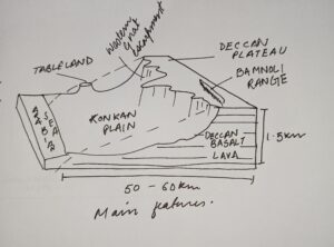 Volcanic eruptions, tectonic uplifts as well as long term erosions are some of the factors that have shaped Deccan Plateau presently with its elevated terrain, deep river valleys and fertile soils.
See less