Home/upsc: geomorphology/Page 2
- Recent Questions
- Most Answered
- Answers
- No Answers
- Most Visited
- Most Voted
- Random
- Bump Question
- New Questions
- Sticky Questions
- Polls
- Followed Questions
- Favorite Questions
- Recent Questions With Time
- Most Answered With Time
- Answers With Time
- No Answers With Time
- Most Visited With Time
- Most Voted With Time
- Random With Time
- Bump Question With Time
- New Questions With Time
- Sticky Questions With Time
- Polls With Time
- Followed Questions With Time
- Favorite Questions With Time
Discuss the impact of glaciation on contemporary landforms and ecosystems.
Impact of Glaciation on Contemporary Landforms and Ecosystems Glaciation, the process where large masses of ice reshape landscapes, has significantly impacted Earth's landforms and ecosystems. While much of the last major glaciation ended around 10,000 years ago, its effects continue to influence coRead more
Impact of Glaciation on Contemporary Landforms and Ecosystems
Glaciation, the process where large masses of ice reshape landscapes, has significantly impacted Earth’s landforms and ecosystems. While much of the last major glaciation ended around 10,000 years ago, its effects continue to influence contemporary geography and biodiversity.
1. Formation of Glacial Landforms
Glaciation leads to the formation of distinctive landforms such as U-shaped valleys, fjords, moraines, and drumlins. These landforms are evident in regions that experienced past glaciation, such as the Himalayas, Alps, and Rocky Mountains. For instance, Norway’s fjords, formed by glacial erosion, are steep-sided valleys that have been submerged by the sea, creating one of the world’s most iconic landscapes. These landforms not only shape the physical geography but also influence human activities like tourism and agriculture.
2. Glacial Lakes and Water Resources
Glaciation has created numerous glacial lakes, which serve as important freshwater resources for both humans and ecosystems. For example, Lake Michigan and Lake Baikal were formed by glacial activity. In contemporary times, these lakes provide water, support biodiversity, and are crucial for regional economies. In the Himalayas, glacial meltwater sustains major rivers such as the Ganges and Indus, which are vital for millions of people in South Asia, especially for agriculture and drinking water.
3. Soil Fertility and Agricultural Productivity
The advance and retreat of glaciers have contributed to the formation of fertile soils by grinding rocks into fine particles, which are then deposited across large areas. This has made certain post-glacial regions highly productive for agriculture. For example, the Great Plains in North America, shaped by glacial movements, are known for their extensive farming due to fertile glacial deposits. These soils are crucial for global food production today.
4. Glacial Retreat and Ecosystem Changes
In the contemporary era, glacial retreat due to global warming is significantly altering ecosystems. As glaciers recede, they leave behind bare landscapes that take centuries to reforest. In places like the Himalayas and the Alps, the melting of glaciers is altering the flow of rivers, affecting not only human water usage but also the ecosystems dependent on glacial runoff. The loss of glaciers is also affecting species such as snow leopards, whose habitats are shrinking due to climate change.
5. Impact on Climate and Weather Patterns
Glaciation has a major influence on regional climate patterns. The presence of large glaciers cools surrounding areas by reflecting solar radiation. As glaciers melt, this cooling effect diminishes, contributing to global temperature rises. In regions like Greenland, the melting of ice is not only contributing to sea level rise but also affecting ocean circulation patterns, with far-reaching impacts on marine ecosystems and global weather patterns.
Conclusion
The legacy of glaciation is evident in the formation of landforms, water resources, and fertile soils that continue to support contemporary ecosystems and human livelihoods. However, the ongoing retreat of glaciers due to climate change is a pressing issue, threatening ecosystems, water availability, and agricultural productivity. Managing the impacts of glacial melt and protecting vulnerable ecosystems is essential for maintaining both ecological balance and human sustainability in the face of climate change.
See lessHow do tectonic processes shape the landscape and influence human settlement patterns?
Tectonic Processes and Their Impact on Landscape and Human Settlements Tectonic processes, including the movement of Earth's plates, volcanic activities, and earthquakes, play a significant role in shaping landscapes and influencing human settlement patterns. The dynamic nature of these processes leRead more
Tectonic Processes and Their Impact on Landscape and Human Settlements
Tectonic processes, including the movement of Earth’s plates, volcanic activities, and earthquakes, play a significant role in shaping landscapes and influencing human settlement patterns. The dynamic nature of these processes leads to the formation of various landforms, which in turn affects the distribution, type, and growth of human settlements.
1. Formation of Mountains and Highlands
Tectonic activities like plate convergence create mountain ranges and highlands. For instance, the Himalayas were formed due to the collision between the Indian Plate and the Eurasian Plate. These regions are often sparsely populated due to harsh climatic conditions, steep slopes, and difficult living conditions. However, they also provide natural resources like minerals, fresh water from glaciers, and timber, attracting certain populations for economic reasons. For example, the Himalayan foothills in India are home to various settlements that rely on tourism and agriculture.
2. Earthquakes and Their Impact on Settlements
Tectonic plate boundaries are zones of frequent earthquake activities. Earthquakes pose significant risks to human settlements, leading to the destruction of infrastructure and loss of life. For example, the 2023 Turkey-Syria earthquake resulted in massive damage, displacing millions. Areas prone to seismic activity, such as Japan and California, have developed advanced earthquake-resistant architecture to mitigate the impact on urban settlements.
3. Volcanic Activity and Fertile Soils
Volcanic eruptions, another outcome of tectonic activity, create volcanic landscapes that can both devastate and enrich the environment. While eruptions may destroy human settlements, the fertile soils left behind, such as in regions surrounding Mount Vesuvius in Italy or Mount Merapi in Indonesia, support dense agricultural populations. These fertile lands have historically attracted human settlements due to their high agricultural productivity.
4. Rift Valleys and Lakes
Tectonic movements also create rift valleys and lakes, providing water sources and fertile lands that attract human settlements. The East African Rift System has produced a series of large lakes, including Lake Victoria and Lake Tanganyika, supporting diverse ecosystems and communities that rely on fishing and agriculture.
5. Coastal Uplift and Seismic Hazards
Tectonic uplift can create new coastal areas by raising land above sea level, leading to new zones for human settlement. However, tectonic activities along coastlines can also lead to tsunami hazards, as seen during the 2004 Indian Ocean Tsunami, which devastated coastal communities across multiple countries. Coastal areas prone to tectonic activity often require disaster preparedness and early warning systems to protect human populations.
Conclusion
Tectonic processes shape the physical landscape, influencing human settlement patterns through the creation of mountains, valleys, and fertile plains. While these processes provide resources and opportunities for human habitation, they also present risks, particularly in regions prone to earthquakes and volcanic eruptions. The ability of societies to adapt to and mitigate these risks—through engineering, disaster management, and sustainable planning—is crucial for ensuring long-term resilience in tectonically active regions.
See lessExplain the formation of thousands of islands in Indonesian and Philippines archipelagos. (150 words) [UPSC 2014]
Formation of Islands in Indonesian and Philippines Archipelagos Tectonic Plate Activity The Indonesian and Philippine archipelagos are formed due to tectonic plate activity. These regions lie at the convergence of several major tectonic plates, including the Pacific Plate, Indo-Australian Plate, andRead more
Formation of Islands in Indonesian and Philippines Archipelagos
Tectonic Plate Activity
The Indonesian and Philippine archipelagos are formed due to tectonic plate activity. These regions lie at the convergence of several major tectonic plates, including the Pacific Plate, Indo-Australian Plate, and the Eurasian Plate. The movement and interaction of these plates lead to volcanic activity and the formation of islands.
Volcanic Activity
Volcanic activity plays a significant role in island formation. In the Indonesian Archipelago, islands like Sumatra and Java are formed from volcanic eruptions along the Ring of Fire, where the Pacific Plate subducts beneath the Indo-Australian Plate. Similarly, in the Philippines, islands like Luzon and Mindanao are created through volcanic eruptions and tectonic uplift.
Recent Examples
The eruption of Krakatoa in 1883, which caused a massive volcanic explosion, significantly reshaped the Indonesian islands. In the Philippines, the formation of Taal Volcano has led to the creation of several new landforms in the region.
Conclusion
See lessThe thousands of islands in the Indonesian and Philippine archipelagos are primarily the result of complex tectonic interactions and volcanic activity in these seismically active regions.
Define mantle plume and explain its role in plate tectonics. (150 words) [UPSC 2018]
Definition and Role of Mantle Plume in Plate Tectonics Definition: A mantle plume is a localized column of hot, buoyant material that rises from deep within the Earth's mantle. This plume is believed to originate near the core-mantle boundary and ascends through the mantle due to its lower density cRead more
Definition and Role of Mantle Plume in Plate Tectonics
Definition: A mantle plume is a localized column of hot, buoyant material that rises from deep within the Earth’s mantle. This plume is believed to originate near the core-mantle boundary and ascends through the mantle due to its lower density compared to the surrounding rocks.
Role in Plate Tectonics:
Mantle plumes, therefore, significantly impact volcanic activity and influence tectonic plate movements by contributing to mantle convection and creating hotspot volcanoes.
See lessHow are the fjords formed? Why do they constitute some of the most picturesque areas of the world? (150 Words) [UPSC 2023]
Fjords are formed through the process of glacial erosion. During the last Ice Age, massive glaciers carved deep, U-shaped valleys into the landscape as they advanced and retreated. When these glaciers melted, the valleys filled with seawater, creating fjords. The key features of fjords include theirRead more
Fjords are formed through the process of glacial erosion. During the last Ice Age, massive glaciers carved deep, U-shaped valleys into the landscape as they advanced and retreated. When these glaciers melted, the valleys filled with seawater, creating fjords. The key features of fjords include their steep cliffs and narrow, deep water channels.
Fjords are often considered some of the most picturesque areas in the world due to their dramatic landscapes. The combination of towering cliffs, often covered in lush vegetation, and serene, deep blue waters creates stunning visual contrasts. The interaction of light with the unique topography and the reflection of mountains and glaciers in the calm waters further enhance their beauty. Additionally, the surrounding natural environment, often untouched by urban development, adds to their scenic allure, making them popular destinations for nature enthusiasts and tourists.
See lessDescribe the characteristics and types of primary rocks. ( 150 words ) [UPSC 2022]
Primary rocks are also known as igneous rocks. They are called primary because igneous rocks originated first from all the rocks. They were formed during formation of upper crust of earth on cooling, solidification and crystallization of hot magma and lava. The characteristics of primary rocks are:Read more
Primary rocks are also known as igneous rocks. They are called primary because igneous rocks originated first from all the rocks. They were formed during formation of upper crust of earth on cooling, solidification and crystallization of hot magma and lava.
The characteristics of primary rocks are:
Types of primary rocks on basis of mode of occurrence:
See lessWhat are endogenic forces? Highlight their types and discuss the role played by them in forming various landforms on the earth.
Endogenic forces are internal processes that originate within the Earth and play a crucial role in shaping its surface. These forces are driven primarily by the heat and energy emanating from the Earth's interior. They are responsible for various geological phenomena and the formation of significantRead more
Endogenic forces are internal processes that originate within the Earth and play a crucial role in shaping its surface. These forces are driven primarily by the heat and energy emanating from the Earth’s interior. They are responsible for various geological phenomena and the formation of significant landforms.
Types of Endogenic Forces
1. Tectonic Movements:
– Plate Tectonics: The movement of Earth’s lithospheric plates over the asthenosphere. This can be convergent (plates move towards each other), divergent (plates move apart), or transform (plates slide past each other).
– Orogenesis (Mountain Building): The process of mountain formation typically at convergent plate boundaries where the collision of tectonic plates leads to the folding, faulting, and uplifting of Earth’s crust.
– Epeirogenesis (Continent Building):Vertical movements of the Earth’s crust leading to the formation and uplift of large continental areas without significant folding.
2. Volcanism:
– Intrusive Volcanism: Occurs when magma cools and solidifies below the Earth’s surface, forming features like batholiths, sills, and dikes.
– Extrusive Volcanism: When magma erupts onto the Earth’s surface as lava, forming volcanic landforms like shield volcanoes, composite volcanoes, and lava plateaus.
3. Seismic Activity:
– Earthquakes: Sudden release of energy in the Earth’s crust causing ground shaking. They occur due to the movement of tectonic plates along faults.
– Faulting and Folding: Faulting involves the breaking and displacement of rocks, while folding involves the bending of rock layers due to stress.
Role in Forming Various Landforms
1. Mountain Ranges:
– Formed primarily through orogenesis at convergent plate boundaries. Examples include the Himalayas, Andes, and Rockies.
2. Volcanic Landforms:
– Shield Volcanoes: Broad, gently sloping volcanoes formed by low-viscosity lava flows (e.g., Mauna Loa in Hawaii).
– Composite Volcanoes (Stratovolcanoes): Steep, conical volcanoes formed by alternating layers of lava and ash (e.g., Mount Fuji in Japan).
– Calderas: Large, basin-shaped depressions formed after the collapse of a volcano following an eruption (e.g., Yellowstone Caldera).
3. Rift Valleys:
– Formed at divergent plate boundaries where the Earth’s crust is pulled apart. Examples include the East African Rift Valley.
4. Ocean Basins:
– Created through the process of seafloor spreading at mid-ocean ridges, where new oceanic crust is formed as tectonic plates diverge.
5. Earthquake-Induced Landforms:
– Fault scarps and rift valleys can be formed due to the displacement of land during earthquakes.
6. Plateaus:
– Elevated flat-topped areas that can be formed by volcanic activity or the uplift of large areas of the Earth’s crust (e.g., Deccan Plateau in India).
Endogenic forces are vital in the dynamic processes that constantly reshape the Earth’s surface, leading to the formation of various landforms and contributing to the geological diversity observed on our planet.
See lessPlate tectonics not only shapes the Earth's surface but also exerts a significant impact on climate change. Delve into the ways in which plate tectonics can modulate climate patterns.
Plate tectonics is the scientific concept that describes the dynamic movement of large, rigid plates that constitute the Earth's outer shell, or lithosphere. Interactions at plate boundaries generate diverse geological phenomena like mountain uplift, ocean basin formation, volcanoes, and earthquakesRead more
Plate tectonics is the scientific concept that describes the dynamic movement of large, rigid plates that constitute the Earth’s outer shell, or lithosphere. Interactions at plate boundaries generate diverse geological phenomena like mountain uplift, ocean basin formation, volcanoes, and earthquakes, shaping Earth’s surface. Amid mounting climate change concerns, understanding the connections between plate tectonics and climate patterns gains importance, acknowledging their role in shaping Earth’s environment.
Ways in which Plate Tectonics Can Modulate Climate Patterns:
The study of plate tectonics not only enhances our comprehension of Earth’s geological history but also offers invaluable insights into the intricate web of forces shaping our planet’s climate. This understanding is pivotal for grasping past climate fluctuations and making informed projections, particularly in the context of the ongoing era of climate change, where proactive measures are crucial for safeguarding our environment and shaping a sustainable future.
See lessHow has plate tectonics shaped the major landforms of the Indian subcontinent? Use examples like the Himalayas, the Indo-Gangetic Plain, and the Western Ghats to explain.
Plate tectonics is a scientific theory proposed by Alfred Wegener in 1912 as the Continental Drift theory. This explains the mechanism of the evolution, nature, and motion of rigid and solid crustal layers of the earth, known as plates, which influence the geological process. These plates interact aRead more
Plate tectonics is a scientific theory proposed by Alfred Wegener in 1912 as the Continental Drift theory. This explains the mechanism of the evolution, nature, and motion of rigid and solid crustal layers of the earth, known as plates, which influence the geological process. These plates interact at boundaries—divergent, convergent, and transform—where significant geological activity occurs.
In the context of the Indian subcontinent, plate tectonics has played a vital role in shaping its diverse landforms like the Himalayan, Indo-Gangetic plain, western ghats, etc.
1. Himalayan Mountain The Himalayan mountain range is a folded mountain system shaped by the ongoing collision of the Indian and Eurasian lithospheric plates. This geological process began approximately millions of years ago during the Cretaceous period, when the Indian plate separated from Gondwana and began drifting northward. As the Indian plate moved towards the Eurasian plate, it began to sink below the Eurasian plate in the ancient Tethys Sea. This subduction led to the uplift of the sedimentary floor of the Tethys Sea due to giant pressure and sedimentation.
The northward movement of the Indian plate led to increasing both pressure and sedimentation. The Immense pressure and heat generated by this collision caused the lower layers of the Eurasian plate to melt, resulting in magma rising upwards. This molten material then solidified to form the parallel ranges of the Himalayan mountain chain.
Himalayan mountains are a direct consequence of the convergent boundary between the Indian and Eurasian plates, where the collision, subduction, and subsequent geological processes over millions of years have shaped this iconic fold mountain range.
2. During the upliftment of the Himalayan, a continuous collision between Indo and Eurasian plates resulted in trouble in the Himalayan and the formation of a deep synclinal depression between the Himalayas and the Indian peninsula.
Through this basin, rivers originating from the Himalayas, such as the Ganges, Brahmaputra, and their tributaries, carried lots of sediments due to precipitation and erosive forces of glaciation and deposited them into the basin over millions of years and this sedimentation gradually filled the depression. Which lead to the formation of the Great Gangetic Plain.
Tectonic interactions between the Indian and Eurasian Plates not only shaped the Himalayan ranges but also promoted the aggregation of fertile alluvial soils in the Gangetic plains.
3. Western Ghats continuous chain of blocked mountains. Western ghats were formed around 200 to 150 million years ago during the breakup of the supercontinent of Gondwana, during this Indian subcontinent separated from Gondwana supercontinent, At that time the southern part of now India was much larger. Around 100 to 80 million years ago due to plate tectonic movements rift valley was formed In the western part of this plateau and subducted in the Arabian Sea, the Eastern part of this rift rotated slightly and left the edge as a mountain named Western Ghats which is known as escarpment of India because of its stiff slope on the western side and gentle slope on east.
In summary, plate tectonics, as explained by Alfred Wegener’s theory of Continental Drift, has a significant impact on Earth’s geological features in the Indian subcontinent. The Indian and Eurasian Plates are continuously colliding, subducting, and moving, leading to the formation of the famous Himalayan mountains. This process has also contributed to the creation of the Great Gangetic Plain and the Western Ghats. These changes have occurred over millions of years, resulting in various landforms and rich soil deposits. This demonstrates how plate tectonics has greatly influenced the geography of the Indian subcontinent.
See lessName geomorphological process involve in deccan plateau formation and explain how this influence its current landscape feature.
Deccan Plateau - process involved and influence on the landscape Deccan Plateau was primarily shaped by the volcanic activity during the Late Cretaceous period, this period experienced extensive lava flows resulting in the formation. Now lets delve deeper into the formation of the deccan plateau ERead more
Deccan Plateau – process involved and influence on the landscape
Deccan Plateau was primarily shaped by the volcanic activity during the Late Cretaceous period, this period experienced extensive lava flows resulting in the formation.
Now lets delve deeper into the formation of the deccan plateau
Enormous volcanic explosions allow a large volume of basaltic lava to spread out over a vast area and harden into layers of basalt. The Deccan Traps were formed by these successive eruptions, producing the characteristics stepped terrains with flat-topped plateaus and deep valleys. The tectonic forces caused by the northward movement of the Indian Plate lifted up the Deccan Plateau. Additionally, India’s separation from Africa due to rifting and drifting of the Indian Plate also contributed to its formation.
The landscape has undergone significant changes over the ages due to weathering and erosion. Rivers such as Krishna and Godavari transport eroded material, creating deep valleys and gorges on the plateau hence contributing to the rough topography of the plateau.
Regur or black cotton soil is formed from the decay of basaltic rock rich in iron, which makes it good for farming. Therefore affecting land use patterns.
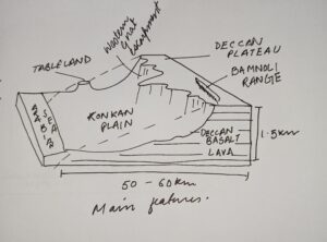 Volcanic eruptions, tectonic uplifts as well as long term erosions are some of the factors that have shaped Deccan Plateau presently with its elevated terrain, deep river valleys and fertile soils.
See less