How can the discrepancies in the formation of the Andes and Himalayas be explained by the theory of plate tectonics? (Answer in 150 words)
Mains Answer Writing Latest Questions
Provide a description of atmospheric circulation worldwide. (Answer in 200 words)
Ritu tyagiLearner
List the ways in which flowing water has influenced the development of landforms. Explain in detail the different depositional characteristics of flowing water as well.(Answer in 200 words)
-
Answer: Running water is considered one of the most important geomorphic agents bringing about the degradation of the land surface. There are two components of running water. One is overland flow on the general land surface as a sheet and another is linear flow as streams and rivers in valleys. SignRead more
Answer: Running water is considered one of the most important geomorphic agents bringing about the degradation of the land surface. There are two components of running water. One is overland flow on the general land surface as a sheet and another is linear flow as streams and rivers in valleys. Significance of running water in the evolution of landforms:
- Most of the erosional landforms made by running water are associated with vigorous and youthful rivers flowing over steep gradients.
- With time, stream channels over steep gradients turn gentler due to continued erosion, and as a consequence, lose their velocity, facilitating active deposition.
- There may be depositional forms associated with streams flowing over steep slopes. But these phenomena will be on a small scale compared to those associated with rivers flowing over medium to gentle slopes.
- The gentler the river channels in gradient or slope, the greater the deposition. When the stream beds turn gentler due to continued erosion, downward cutting becomes less dominant lateral erosion of banks increases and as a consequence, the hills and valleys are reduced to plains.
- Overland flow causes sheet erosion. Depending upon irregularities of the land surface, the overland flow may concentrate into narrow to wide paths forming rills, gullies, and ultimately valleys.
Depositional Features of Running Water
Feature Characteristics Diagram Alluvial Fans Alluvial fans are formed when streams flowing from higher levels break into foot slope plains of low gradient. Normally very coarse load is carried by streams flowing over mountain slopes. This load becomes too heavy for the streams to be carried over gentler gradients and gets dumped and spread as a broad low to high cone-shaped deposit called an alluvial fan. 
Deltas Deltas are like alluvial fans but develop at a different location. The load carried by the rivers is dumped and spread into the sea. If this load is not carried away far into the sea or distributed along the coast, it spreads and accumulates as a low cone. Unlike in alluvial fans, the deposits making up deltas are well very sorted with clear stratification. 
Floodplains, Natural Levees and Point Bars Deposition develops a floodplain just as erosion makes valleys. Floodplain is a major landform of river deposition. Large-sized materials are deposited first when the stream channel breaks into a gentle slope. Thus, normally, fine-sized materials like sand, silt, and clay are carried by relatively slow-moving waters in gentler channels usually found in the plains and deposited over the bed and when the waters spill over the banks during flooding above the bed. Natural levees are found along the banks of large rivers. They are low, linear, and parallel ridges of coarse deposits along the banks of rivers, quite often cut into individual mounds. Point bars are also known as meander bars. They are found on the concave side of meanders of large rivers and are sediments deposited in a linear fashion by flowing waters along the bank. 
The study of running water in the evolution of landforms helps us understand and appreciate the diversity of landforms on the surface of the earth.
See less
Examine the effects of plateaus on regional and global climatic patterns.
-
Plateaus, elevated flatlands found across the globe, have a significant impact on both regional and global climate patterns. Their unique geographical features play a crucial role in shaping weather conditions and atmospheric circulation, affecting not only the areas they cover but also having far-rRead more
Plateaus, elevated flatlands found across the globe, have a significant impact on both regional and global climate patterns. Their unique geographical features play a crucial role in shaping weather conditions and atmospheric circulation, affecting not only the areas they cover but also having far-reaching consequences on a global scale.
Impact of Plateaus on Regional Climate Patterns
- Rain Shadow Effect: A classic example is the Western Ghats in parts of Maharashtra and Gujarat, where the Arabian Sea’s moist air rises, leading to heavy rainfall on the windward side and creating the rain shadow effect in the Deccan Plateau to the east, resulting in a semi-arid to arid climate in marathwada region.
- Temperature Extremes: Plateaus, due to their elevated terrain, experience pronounced temperature variations. The Colorado Plateau in the United States exemplifies this with scorching summers and harsh winters, influenced by its high elevation.
- Monsoon Modification: Plateaus play a pivotal role in modifying regional monsoon patterns. The Tibetan Plateau, often referred to as the “Roof of the World,” heats up significantly during the summer months. This intense heating influences the circulation of the Indian Monsoon winds.
- Localized Climate Zones: Plateaus can create distinct microclimates within regions. The Mexican Plateau, for instance, exhibits a temperate climate, in stark contrast to the tropical conditions prevalent in the surrounding lowland areas.
- River Sources: Many major rivers find their origins on plateaus. The Plateau of Tibet, often referred to as the “Water Tower of Asia,” is the source of several vital Asian rivers, including the Brahmaputra, the Yangtze, and the Indus.
- Biodiversity Hotspots: The diverse topography and climate found on plateaus can foster rich biodiversity. The Ethiopian Plateau, for example, is renowned for its unique flora and fauna, including species like the Ethiopian wolf and various endemic plant species.
- Agriculture and Farming: Plateau regions with fertile soils and reliable water sources are often ideal for agriculture. The Deccan Plateau in India is a prime example of a plateau region that supports extensive agricultural activities, including the cultivation of crops like cotton, soybeans, and Millets.
- Water Resources: Plateaus frequently store substantial groundwater reserves due to their geological characteristics. These underground aquifers serve as vital sources of freshwater for the surrounding regions, especially in arid or semi-arid areas.
Impact of Plateaus on Global Climate Patterns
- Atmospheric Circulation: Plateaus significantly influence global wind patterns and jet streams. Eg: The Tibetan Plateau’s heating during the summer months leads to the strengthening of the jet stream, influencing the path of storms and weather systems well beyond Asia.
- Albedo Effect: Snow-covered plateaus, like Tibet, exhibit a high albedo, meaning they reflect a significant amount of incoming solar radiation back into space. This reflective quality of plateaus has a profound effect on Earth’s energy balance and temperature regulation.
- Climate Change: Changes in plateau climates can trigger ripple effects on a global scale. The melting of glaciers on plateaus, driven by global warming, contributes to rising sea levels. The water released from melting glaciers flows into oceans, impacting coastal regions worldwide.
- Carbon Sink: Certain plateaus, such as the Altiplano in South America, function as carbon sinks. These plateaus have unique ecosystems and soils that absorb and store carbon dioxide from the atmosphere, thus mitigating the accumulation of GHGs and addressing climate change.
- Ocean Currents: Plateaus can have far-reaching impacts on ocean currents, which, in turn, influence global weather patterns. The interaction between the Antarctic Plateau and the Southern Ocean, for example, plays a significant role in shaping ocean circulation in the southern hemisphere.
- Atmospheric Stability: The topographic features of plateaus can disrupt the movement of air masses and influence the development of weather systems. This can result in the creation of high-pressure and low-pressure areas, affecting global atmospheric circulation.
- Oceanic and Continental Contrasts: Plateaus create sharp contrasts between continental and oceanic climates. Eg: the contrast between the Tibetan Plateau and the Indian Ocean plays a pivotal role in shaping the Asian monsoon system, impacting weather patterns across Asia and beyond.
Overall, plateaus wield a profound influence on both regional and global climate patterns, playing a pivotal role in shaping our planet’s complex climate dynamics. Recognizing the significance of plateaus is essential for understanding and addressing climate change and its repercussions on both regional and global scales.
See less
Lala RamLearner
Describe in brief the different landforms that are the result of glacier movement in terms of erosion and depositional processes. (Answer in 200 words)
-
Glaciers are powerful agents of erosion and deposition, shaping landscapes through their movement and the ice melt processes. Erosional landforms include: Glacial Valleys (U-shaped valleys): Carved out by the erosive action of glaciers, these valleys have steep sides and a broad, flat bottom, contraRead more
Glaciers are powerful agents of erosion and deposition, shaping landscapes through their movement and the ice melt processes. Erosional landforms include:
- Glacial Valleys (U-shaped valleys): Carved out by the erosive action of glaciers, these valleys have steep sides and a broad, flat bottom, contrasting with V-shaped river valleys.
- Cirques: Bowl-shaped depressions at the head of glacial valleys, formed by the plucking and abrasion of ice. They often contain tarns (small mountain lakes).
- Arêtes: Sharp ridges formed between two glacial valleys or cirques, as the ice erodes both sides.
- Horns: Pyramid-shaped peaks formed when several cirques erode a mountain peak from multiple sides.
Depositional landforms include:
- Moraines: Accumulations of unsorted rock debris carried and deposited by glaciers. Types include terminal moraines (at the glacier’s end), lateral moraines (along the sides), and medial moraines (formed when two glaciers merge).
- Drumlins: Smooth, elongated hills of glacial till, shaped by the movement of ice sheets over older moraines.
- Erratics: Large boulders transported and deposited by glaciers, often composed of rock different from the surrounding terrain.
- Outwash Plains: Flat areas of sand and gravel deposited by meltwater streams from glaciers.
Glaciers continually reshape landscapes through a combination of erosional and depositional processes, leaving behind distinctive landforms that reflect their dynamic movement and influence on the Earth’s surface.
See less
Manoj SinghLearner
The Earth’s ocean currents are crucial for maintaining marine life and controlling the temperature. Talk about it. (Answer in 150 words)
-
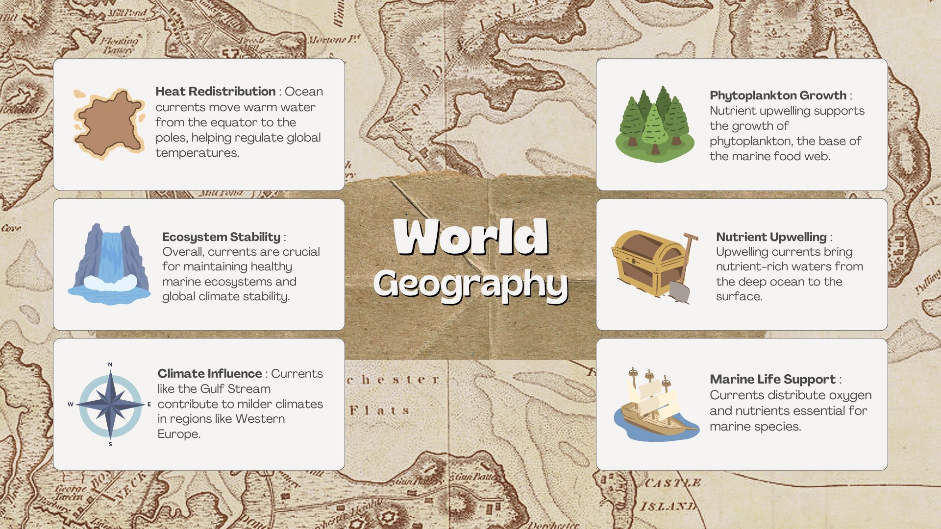
Ocean currents are vital to the Earth's climate and marine ecosystems. These currents act as massive conveyors, redistributing heat from the equator towards the poles, thereby regulating global temperatures. For instance, the Gulf Stream carries warm water from the Gulf of Mexico to the North AtlantRead more
Ocean currents are vital to the Earth’s climate and marine ecosystems. These currents act as massive conveyors, redistributing heat from the equator towards the poles, thereby regulating global temperatures. For instance, the Gulf Stream carries warm water from the Gulf of Mexico to the North Atlantic, contributing to milder climates in Western Europe.
In addition to climate regulation, ocean currents are essential for supporting marine life. They facilitate the distribution of nutrients and oxygen, which are critical for the survival of various marine species. Upwelling currents, for example, bring nutrient-rich waters from the deep ocean to the surface, fueling the growth of phytoplankton, the foundation of the marine food web. This, in turn, supports diverse marine populations, including fish, birds, and marine mammals.
Overall, ocean currents are indispensable for sustaining healthy marine ecosystems and ensuring the stability of global climate patterns, highlighting their significance for life on Earth.
See less
Saurabh SoniLearner
Evaluate the connection between the Indian monsoon and El Nino-Southern Oscillation (ENSO) phenomena critically.
-
El Nino-Southern Oscillation (ENSO) occurs due to a periodical variation in temperatures between the ocean and atmosphere in the east-central Equatorial Pacific. It has two phases: El Niño, characterized by warmer ocean temperatures, and La Niña, characterized by cooler ocean temperatures. It signifRead more
El Nino-Southern Oscillation (ENSO) occurs due to a periodical variation in temperatures between the ocean and atmosphere in the east-central Equatorial Pacific. It has two phases: El Niño, characterized by warmer ocean temperatures, and La Niña, characterized by cooler ocean temperatures. It significantly influences weather patterns globally, including the Indian monsoon system.
Relationship between ENSO Events and the Indian Monsoon
- Rainfall Patterns: During the ENSO phenomena, the Indian subcontinent experiences altered rainfall patterns. Eg: the severe drought in 2002 was due to a strong El Niño event. Conversely, the 1988 monsoon was one of the wettest on record, a direct effect of La Niña.
- Onset Timing: The onset of the monsoon can be significantly affected by ENSO events, a classic example being the delayed onset in 2014 due to El Niño influences, which disrupted the agricultural calendar extensively.
- Regional Variations: ENSO events foster significant regional disparities in weather conditions across India. For instance, during the 2006 El Niño, while central India experienced a dry spell, northeast India faced heavy floods due to irregular rainfall patterns.
- Monsoon Depressions: La Niña encourages more monsoon depressions, as seen in 2010, resulting in a better-than-average monsoon season with bountiful rains, which, while aiding agriculture, also brought about challenges like flooding in several regions, including Punjab and Haryana.
- Historical Events: For instance, El Niño events of 1877 and 1899 affected Indian monsoon reducing rainfall and caused severe droughts, showcasing a consistent pattern of distress during such periods. Understanding this historical trend is crucial for modern predictive and preparatory strategies.
Impact of the Relationship between ENSO events and the Indian Monsoon
- Food Security: During ENSO events, particularly El Niño, the rainfall patterns in India become erratic which directly affects food security. For example, the El Niño event in 2002 resulted in a substantial decline in food grain production, affecting the food security of millions.
- Water Scarcity: Water scarcity becomes a pertinent issue in El Niño years. The year 2016 was marked with acute water shortages in various parts of India, necessitating even train services to transport water to the affected areas.
- Biodiversity: Changing monsoon patterns have adverse effects on biodiversity. The Western Ghats, a biodiversity hotspot in India, witnessed severe disruptions in the ecosystems during the El Niño years, leading to loss of species and altered migration patterns.
- Energy Sector: Hydroelectric power generation, which is a significant contributor to India’s energy sector, faces challenges due to irregular water availability. Eg: during 2023 summers (partially an El Niño year), power demand has touched the record height of 233 GW.
- Rural Livelihoods: Rural populations, chiefly reliant on agriculture, face the brunt of ENSO events. The farmer distress witnessed in various states during 2002 and 2009 were largely due to the El Niño phenomena affecting the monsoons adversely.
- Inflation: Agricultural output fluctuations lead to inflation, affecting the daily life of common people. During the 2009 El Niño event, India witnessed a surge in the prices of essential commodities, burdening the common man with increased costs, due to its double digit inflation rate (10.88%).
Way Ahead
- Improved Forecasting: Learning from Australia’s Bureau of Meteorology which utilizes state-of-the-art computational facilities to forecast weather patterns, India can further modernize the IMD with higher computational prowess for accurate predictions during ENSO events.
- Water Conservation: Israel’s success story in water management through desalination and recycling of wastewater can serve as a benchmark. India can develop policies promoting these technologies to sustain water resources during erratic monsoon periods induced by ENSO events. Ex- Sujalam campaign.
- Agricultural Adaptation: Taking cue from the SRI (System of Rice Intensification) method, which proved successful in Tamil Nadu, promoting such innovative agricultural practices nationally could enhance productivity despite adverse climatic conditions.
- International Cooperation: Collaborating with initiatives like the Global Climate Observing System (GCOS) can help in assimilating data and research to better understand the ENSO events and devise strategies at a global level.
- Leveraging technology: Promoting the development and use of Genetically Modified (GM) crops that are resistant to fluctuating weather conditions. Additionally, developing mobile apps to advise farmers on the best practices during varying climatic conditions.
Overall, the El Niño Southern Oscillation (ENSO) events have a profound impact on the Indian monsoon, affecting various sectors in India, including agriculture, biodiversity, and health. Adopting these strategies, India can pave a forward-thinking path in managing the impacts of ENSO events on its monsoonal patterns, focusing on sustainability and resilience in various sectors.
See less
Describe the idea of diastrophism and the procedures that go along with it.(Answer in 200 words)
-
Diastrophism: Geomorphologically, the term Diastrophism refers to a geomorphic process of crust deformation. This process leads to the formation of continents and ocean basins. Diasreophim is involved in two distinct processes that are classified as: Epeirogenic Processes: These processes are theRead more
Diastrophism:
Geomorphologically, the term Diastrophism refers to a geomorphic process of crust deformation. This process leads to the formation of continents and ocean basins.
Diasreophim is involved in two distinct processes that are classified as:
Epeirogenic Processes: These processes are the vertical earth movements of the crust deformation created by endogenic forces These processes cause continental building by warping large parts of the Earth’s crust. There are two processes submergence and emergence.
- Submergence: This process is caused by the rising sea level relative to the land surface. This downward movement may lead to the formation of rias and estuaries.
- Emergence: This process is driven by falling sea levels relative to the land.or upliftment of the land that leads to the formation of marine terraces and coral reefs.
Orogenic processes: Geologically, these dystrophic processes are caused by the horizontal movement of the endogenic forces that may lead to the formation of Mountain-Building.
The processes driven by the influence of dystrophic orogenic processes are:
- Transitional forces: These processes may cause faulting and cracking that exceed the crust by stressing and shearing the rock’s strength.
- Compressional forces: These processes may cause folding and warping that are subjected to compression within the crustal rocks.
Shyamlal SharmaLearner
Examine the fundamental causes of the “Dead Zones” that are appearing more frequently in marine environments.
-
Marine organisms need oxygen to survive and if there is deficiency of oxygen demand it causes that area as a dead zone which also lead to a nutrient pollution in Marine water ecosystem. 1. climate change: temperature increases and water becomes warm and lighter and lose the ability to hold oxygen anRead more
Marine organisms need oxygen to survive and if there is deficiency of oxygen demand it causes that area as a dead zone which also lead to a nutrient pollution in Marine water ecosystem.
See less
1. climate change: temperature increases and water becomes warm and lighter and lose the ability to hold oxygen and restrict the distribution of oxygen into the water.
2. Eutrophication: It creates hypoxic condition in water due to algae bloom.
3. Nutrient pollution: surplus of nutrients from agricultural run off, usage of fertilizers ,sewage through this enters into the water body and consume oxygen which leads to less oxygen supply.
4. Pollution: Other than nutrient pollution heavy metals, chemicals, oil skills, industrial waste, domestic waste, can also pollute marine ecosystem and creates dead zone areas.
example , Mexico experiences one of the largest dead zone globally due to nutrient rich to run out from the Mississippi River basi
Dead zones in Marine ecosystem requires efforts to reduce pollution eutrophication climate change and need to improve water quality through proper waste water management good environmental policies and mindful agricultural practices.
Pranjal shekhBegginer
Highlight the variations between the troposphere and stratospheric in the ozone generation and function. Talk about the several approaches to lessening the effects of tropospheric ozone. (Answer in 250 words)
-
Ozone (03) is a highly reactive gas composed of three oxygen atoms. It is both a natural and a man-made product that occurs in the Earth's upper atmosphere (stratosphere) and lower atmosphere oxygen (troposphere). Depending on where it is in the atmosphere, ozone affects life on Earth in either goodRead more
Ozone (03) is a highly reactive gas composed of three oxygen atoms. It is both a natural and a man-made product that occurs in the Earth’s upper atmosphere (stratosphere) and lower atmosphere oxygen (troposphere). Depending on where it is in the atmosphere, ozone affects life on Earth in either good or bad ways. Formation of tropospheric and stratospheric ozone Tropospheric or ground-level ozone is formed primarily from photochemical reactions between two major classes of air pollutants, volatile organic compounds (VOCs) and nitrogen oxides (NOx). NOx and VOC break apart in the presence of intense sunlight and recombine into new structures, creating ozone. It is created by human activities as emissions from industrial facilities and electric utilities, motor vehicle exhaust, gasoline vapor, and chemical solvents are some of the major sources of NOx and VOC. On the other hand, stratospheric ozone is formed naturally through the interaction of solar ultraviolet (UV) radiation with molecular oxygen (02). Solar ultraviolet radiation breaks apart one oxygen molecule (02) to produce two oxygen atoms (20) and each of these highly reactive atoms combines with an oxygen molecule to produce an ozone molecule (03). These reactions occur continually whenever solar ultraviolet radiation is present in the stratosphere. Role of tropospheric and stratospheric ozone The tropospheric ozone or bad ozone can trigger a variety of health problems including chest pain, coughing, and throat irritation. It is also a major component of urban smog, which can worsen bronchitis and emphysema, trigger asthma, and permanently damage lung tissue. Further, bad ozone also damages vegetation and ecosystems as it leads to reduced agricultural crop and commercial forest yields, reduced growth and survivability of tree seedlings, and increased susceptibility to diseases, pests, and other stresses such as harsh weather. Whereas, the stratospheric ozone absorbs a portion of UV (Ultra Violet) light called UVB from the sun, preventing it from reaching the planet’s surface. Thus, it protects from many harmful effects, including skin cancers, cataracts, and harm to some crops and marine life. But this good ozone is gradually being destroyed by man-made chemicals referred to as ozone-depleting substances (ODS), including chlorofluorocarbons (CFCs), hydrochlorofluorocarbons (HCFCs), etc.
Strategies to prevent the formation of tropospheric ozone.
- Fossil fuels & transport sector
- Vapor recovery nozzles at the gasoline pumps to reduce refueling emissions.
- Cleaner burning gasoline is reformulated through catalytic convertors to reduce VOC, NOx, etc.
- Strict NOx emission limits for power plants and industrial combustion sources.
- Agriculture sector:
- Apply intermittent aeration of continuously flooded rice fields.
- Introduce selective breeding to reduce emission intensity and increase production.
- Waste management
-
- Separate and treat biodegradable municipal waste, and turn it into compost or bioenergy.
- Upgrade wastewater treatment with gas recovery and overflow control.
- Better Monitoring of Ozone mitigation initiatives such as that of long-range Transboundary Air Pollution through the implementation of the Gothenburg protocol and effective forecasting through SAFAR (System of Air Quality and Weather Forecasting).
The Government has further taken initiatives such as the National Clean Air Programme (NCAP), Graded Response Action Plan (GRAP), etc. to check ozone pollution and improve air quality. There is a need for the effective implementation of multi-faceted programs to cut NOx and VOC emissions from vehicles, industrial facilities, and electric utilities. Voluntary programs may also be started to encourage the communities to adopt practices, such as carpooling, to reduce harmful emissions.
See less - Fossil fuels & transport sector
The formation of the Andes and Himalayas can be explained by the theory of plate tectonics through the interaction of different types of plate boundaries. Andes Formation: Subduction Zone: The oceanic Nazca Plate subducts beneath the continental South American Plate. Convergent Boundary: This oceaniRead more
The formation of the Andes and Himalayas can be explained by the theory of plate tectonics through the interaction of different types of plate boundaries.
Andes Formation:
Himalayas Formation:
Thus, while both mountain ranges arise from convergent plate boundaries, the Andes involve oceanic-continental subduction, and the Himalayas result from continental-continental collision, leading to differences in their geological characteristics and formation processes.
See less