Evaluate the connection between the Indian monsoon and El Nino-Southern Oscillation (ENSO) phenomena critically.
Mains Answer Writing Latest Questions
Aditya NairBegginer
What does moving away from a mid-ocean ridge say about sea floor spreading, and how does the age of oceanic crust change?


Kiran SrivastavaBegginer
Examine the elements that led to the creation of the Sargasso Sea and give its exact position. Moreover, explain its worldwide importance.
-
The Sargasso Sea, located in the North Atlantic Ocean, is unique for its clear, warm waters and floating seaweed called Sargassum. It is bordered by four ocean currents: the Gulf Stream to the west, the North Atlantic Current to the north, the Canary Current to the east, and the North Atlantic EquatRead more
The Sargasso Sea, located in the North Atlantic Ocean, is unique for its clear, warm waters and floating seaweed called Sargassum. It is bordered by four ocean currents: the Gulf Stream to the west, the North Atlantic Current to the north, the Canary Current to the east, and the North Atlantic Equatorial Current to the south. These currents form a gyre, a large system of rotating ocean currents, which is the primary factor responsible for the formation of the Sargasso Sea.
This sea is characterized by its distinctive ecosystem, with the Sargassum providing habitat and breeding grounds for various marine species, including eels, fish, and turtles. The lack of land boundaries and nutrient-poor waters result in low biological productivity, making it an oligotrophic region.
- Globally, the Sargasso Sea holds significant ecological importance. It serves as a critical habitat for the early life stages of European and American eels, which are economically and ecologically vital.
- Additionally, it plays a role in carbon sequestration; the Sargassum absorbs carbon dioxide, which helps mitigate climate change.
- The Sargasso Sea also supports biodiversity, providing a refuge for endangered species and acting as a natural laboratory for studying marine ecosystems and climate change impacts.
Overall, the Sargasso Sea’s formation and ecological significance underscore its importance in oceanographic and environmental research, contributing to global biodiversity and climate regulation.
See less
Shivam tiwariLearner
Give a general taxonomy of air masses and elaborate on the process of air mass development.
-
An air mass is a large volume of air defined by its temperature and water vapour content. The geographical region and the specific conditions of the region where an air mass forms influence its characteristics significantly. Understanding the formation and classification of air masses is pivotal inRead more
An air mass is a large volume of air defined by its temperature and water vapour content. The geographical region and the specific conditions of the region where an air mass forms influence its characteristics significantly. Understanding the formation and classification of air masses is pivotal in meteorology, offering insights into weather patterns and climatic conditions.
Process of Air Mass Formation
- Source Region: Air masses form in large, stable regions known as source regions. A case in point is the Arctic region where continental polar air masses develop, characterized by their cold and dry properties due to the extreme conditions prevailing in this polar region.
- Temperature and Humidity: The specific climate of the source region moulds the temperature and humidity level of an air mass. The maritime tropical air masses, which develop over the Caribbean sea, for instance, are generally hot and carry high moisture content.
- Stability and Duration: They acquire characteristics of their source region over an extended period. Eg: the maritime air masses influencing the South Asian monsoons stabilize over the Indian Ocean for several days, absorbing moisture before moving towards the Indian subcontinent.
- High-Pressure Systems: These systems, especially in polar and subtropical regions, facilitate the birth of air masses. The Siberian High, a high-pressure system during winter, fosters very cold and dry air masses which influence a large part of the Asian continent.
- Seasonal Variations: Seasons play a pivotal role; like, the continental air masses from Canada are distinctly colder and drier during winter, contrasting sharply with their warmer and slightly more humid nature in summer, affecting the North American weather patterns accordingly.
- Solar Radiation: It has a direct bearing on an air mass’s temperature. Equatorial regions, receiving high solar radiation all year round, give birth to warm and humid air masses, which significantly impact the tropical climate, making it hot and wet most of the year.
- Topography: The geographical layout of a region, including features like mountains, influence the forming air masses. Eg: the air masses developing over the Rockies are distinctively dry due to the shadow effect and vary considerably in temperature due to the changing elevations.
- Wind and Convergence Zones: Wind patterns aid air mass formation, especially in areas where different air masses converge, such as the ITCZ where the meeting of trade winds fosters the development of warm, humid air masses, significantly influencing the tropical weather conditions.
General Classification of Air Masses
- Maritime Tropical (mT): They are known for their warm and humid characteristics, originating from tropical oceanic areas. Eg: the air masses generated over the Gulf of Mexico, which play a significant role in shaping the weather of southeastern regions of the USA.
- Continental Tropical (cT): They are warm yet dry, forming over desert areas like the Sahara Desert. These masses greatly influence North African weather, rendering it extremely dry and hot. The hot and dry winds can sometimes carry desert dust over long distances
- Maritime Polar (mP) : Cold and humid, these air masses are conceived over cold ocean waters in regions like the North Atlantic. They influence Western European climates, bringing cold and moist weather patterns, and are largely responsible for the unpredictable weather in the UK.
- Continental Polar (cP): Forming over land areas in polar regions, these cold and dry air masses often originate in Siberia during the winter season. They influence the cold weather patterns in East Asia, with temperatures plunging significantly during winter.
- Continental Arctic (cA): These air masses, born in Arctic regions, are recognized for extremely low temperatures. Their incursion into North America, especially Canada, results in frigid conditions, dictating a harsh winter season characterized by substantially low temperatures.
Understanding these classifications helps in predicting weather phenomena, aiding meteorologists in forecasting weather patterns accurately and understanding climate dynamics at various geographical locations. It forms the crux of weather prediction science, offering insights into how different regions experience diverse weather patterns.
See less
Aditya NairBegginer
Explain the features of the trade wind inversion and how it affects tropical weather patterns.
-
A trade wind inversion (TWI) is a meteorological phenomenon characterized by a layer of warm air aloft that acts as a lid, trapping cooler air beneath it. It originates on the eastern sides of the tropical oceans, and steadily increases in height and decreases in strength moving westward and equatorRead more
A trade wind inversion (TWI) is a meteorological phenomenon characterized by a layer of warm air aloft that acts as a lid, trapping cooler air beneath it. It originates on the eastern sides of the tropical oceans, and steadily increases in height and decreases in strength moving westward and equatorward.
Characteristics of Trade Wind Inversion:
- Temperature Gradient: Trade wind inversions are marked by a distinct temperature difference between the warm air above and the cooler air below. This temperature contrast is responsible for the inversion’s stability.
- Altitudinal Variations: The height of the trade wind inversion increases as you move westward and equatorward from its origin point in the eastern parts of oceans. For instance, in the North Pacific, a trade wind inversion ascends from less than 500 m at the California coast to over 2000 m at Hawaii.
- Strength Variability: The strength of the trade wind inversion decreases as you move westward and equatorward from its origin point in the eastern parts of oceans. Thickness of the inversion layer can vary from tens of meters to more than 1000 meters.
- Average thickness of the inversion layer is about 400 m.
- Stability: The warm air layer aloft creates stable atmospheric conditions, inhibiting vertical air movement, convection, and mixing. This stability can lead to calm and clear weather in the region beneath the inversion, as seen in the Tropical North Atlantic region across all seasons.
- Persistence: Trade wind inversions can persist for extended periods, often lasting days or even weeks, making them a prominent feature in the affected regions.
- Trapping of Moisture and Pollution: These inversions act as a barrier that can trap moisture, pollutants, and aerosols beneath them. This can lead to the formation of fog, low-level clouds, and poor air quality, especially in coastal areas.
Effects of Trade Wind Inversion on the Weather Conditions in the Tropics:
- Stable Atmospheric Conditions and the Suppression of Convection: Trade wind inversions create stable atmospheric conditions. This stability inhibits the vertical movement of air, which is essential for the development of thunderstorms and other convective activity. As a result, areas under a trade wind inversion tend to experience fewer thunderstorms and less intense rainfall.
- For example, in the Tropical North Atlantic region, TWI serves as an important stabilizing mechanism.
- Temperature Profile: The temperature lapse rate in a trade wind inversion is inverted, meaning that temperature increases with height instead of decreasing. This leads to a noticeable temperature difference between the surface and the upper levels of the inversion layer, which significantly influences local weather conditions. It is exemplified by the TWI in the Caribbean Basin.
- Moisture Trapping: The inversion layer acts like a cap, preventing the upward movement of moist air. This can lead to the accumulation of moisture near the surface, resulting in higher humidity levels. An illustrative example of this effect can be observed in the TWI found in the Hawaii region.
- Cloud Formation and Fog: The inversion often leads to the formation of low-level clouds or fog. Moist air near the surface is trapped beneath the warm, dry air in the inversion layer. This can lead to the development of stratocumulus clouds or fog, especially over coastal regions.
- Limited Vertical Mixing: The presence of an inversion limits the vertical mixing of air masses. This means that pollutants, such as smog or industrial emissions, can become trapped near the surface, potentially leading to poor air quality.
The trade wind inversion is a distinctive meteorological phenomenon observed in the tropics. These trade wind inversions exert a strong influence on the tropical climate, contributing to both the unique weather patterns and challenges faced in these regions. Understanding these characteristics and effects is essential for meteorologists and climate scientists studying tropical meteorology.
See less
How can AI be used to combat climate change and environmental degradation?
-
Climate change refers to long-term changes in the Earth's climate, such as temperature, precipitation, wind patterns, and other climatic variables. While certain changes occur naturally, current data indicates that human actions, notably using fossil fuels and deforestation, play a significant role.Read more
Climate change refers to long-term changes in the Earth’s climate, such as temperature, precipitation, wind patterns, and other climatic variables. While certain changes occur naturally, current data indicates that human actions, notably using fossil fuels and deforestation, play a significant role. These activities raise greenhouse gas concentrations in the atmosphere, contributing to global warming and a few other consequences such as rising sea levels, and ecological changes.
See less
Artificial intelligence (AI) has emerged as a crucial ally in the battle against climate change, analyzing vast amounts of data, detecting patterns, and making accurate predictions. Machine learning algorithms spot trends and provide precise forecasts about future climate scenarios, aiding policymakers in planning effective measures. It also helps integrate and manage renewable energy sources by predicting production based on weather patterns and stabilizing energy networks. AI-powered environmental monitoring improves real-time analysis for deforestation, air pollution, and wildlife conservation, thereby enhancing regulatory compliance and ecosystem protection. While, AI’s high energy consumption, resource intensity, data privacy concerns, potential biases, system vulnerabilities, and risk of economic displacement pose significant challenges. In conclusion, AI holds significant potential in the fight against climate change however, addressing the associated challenges is crucial to ensure that AI’s application in climate.
What are some practical ways individuals can reduce their carbon footprint in daily life?
-
This answer was edited.
Individuals can significantly reduce their carbon footprint through several practical steps: 1. Transportation: Use public transportation, carpool, bike, or walk instead of driving alone. If possible, switch to electric or hybrid vehicles. 2. Energy Consumption: Reduce energy use at hoRead more
Individuals can significantly reduce their carbon footprint through several practical steps:
1. Transportation: Use public transportation, carpool, bike, or walk instead of driving alone. If possible, switch to electric or hybrid vehicles.
2. Energy Consumption: Reduce energy use at home by turning off lights and appliances when not in use, using energy-efficient bulbs, and investing in energy-efficient appliances. Consider installing solar panels.
3. Diet: Adopt a plant-based diet or reduce meat and dairy consumption. Local, seasonal produce often has a lower carbon footprint.
4. Waste Reduction: Reduce, reuse, and recycle. Avoid single-use plastics, compost organic waste, and support products with minimal packaging.
5. Water Conservation: Use water-saving fixtures, fix leaks, and be mindful of water use in daily activities.
6. Shopping Habits: Buy less, choose sustainable and eco-friendly products, and support companies with green practices.
7. Home Insulation: Improve home insulation to reduce heating and cooling energy needs.
8. Renewable Energy: If possible, switch to a renewable energy provider.
By integrating these actions into daily routines, individuals can make a significant impact on reducing their carbon footprint and contribute to a more sustainable future.
See less
-
Deforestation is the removal of forests usually as a result of deliberate human action such as cutting down trees for timber, fuelwood or to clear land for agriculture, urbanization or other purposes. Contributions of Deforestation to climate change - Disrupts the carbon cycle by releasing stored caRead more
Deforestation is the removal of forests usually as a result of deliberate human action such as cutting down trees for timber, fuelwood or to clear land for agriculture, urbanization or other purposes.
Contributions of Deforestation to climate change –
- Disrupts the carbon cycle by releasing stored carbon dioxide (CO2) through tree cutting and decomposition.Carbon cycle disruption releases excess CO2, trapping heat ,and accelerating global warming and climate change.
- Releases greenhouse gases through tree cutting, decomposition and soil disturbance, emitting carbon dioxide (55-65%), methane (20-25%) and nitrous oxide (5-10%), totaling 15-20% of global.Greenhouse gas emissions trap heat, warming the planet, and driving climate change and weather extremes.
- Disrupts climate regulation by removing forests that moderate temperature, precipitation and weather patterns, altering global water cycles and exacerbating climate extremes, impacting regional and global climate stability significantly.
Deforestation’s devastating impact on climate regulation, biodiversity and ecosystems necessitates urgent action, including sustainable land use practices, reforestation efforts and d policy changes to protect our planet’s precious forests.
See less
Suman DeviBegginer
-
World Health Organization (WHO) defines Climate change as the long term changes in temperature and precipitation patterns, which can have significant impacts on human health, particularly in vulnerable populations. Primary causes of Climate Change - Volcanic eruptions release ash, sulfur dioxide andRead more
World Health Organization (WHO) defines Climate change as the long term changes in temperature and precipitation patterns, which can have significant impacts on human health, particularly in vulnerable populations.
Primary causes of Climate Change –
- Volcanic eruptions release ash, sulfur dioxide and aerosols into the atmosphere, reflecting sunlight, cooling global temperatures and altering climate patterns.
- Changes in Earth’s orbit alter the amount of solar energy received, affecting global temperatures and triggering ice ages or warming.
- Changes in ocean currents and cycles shift heat distribution by impacting regional temperatures, weather patterns and global climate conditions.
- Plate tectonics reshape Earth’s surface, altering ocean currents, continent positions and greenhouse gas release, influencing long term climate patterns slowly.
Human activities contribution to the causes of Climate Change –
- Burning fossil fuels releases carbon dioxide, methane and nitrous oxide, driving global warming rapidly.
- Deforestation and land use changes release carbon, disrupt ecosystems and exacerbate global warming significantly.
- Agriculture contributes to climate change through methane emissions, nitrous oxide release and deforestation.
- Consumer demand for resource intensive goods fuels carbon emissions, deforestation and unsustainable production practices.
- Waste decomposition releases methane and nitrous oxide, potent greenhouse gases fueling climate change.
- Industrial processes and manufacturing release greenhouse gases, driving climate change through emissions growth.
- Transportation emissions from vehicles, ships and planes release CO2, fueling global warming rapidly worldwide.
Climate change threatens our planet, but collective action, sustainable living and renewable energy can mitigate its impacts by securing a safer and healthier future for all.
See less
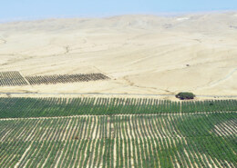
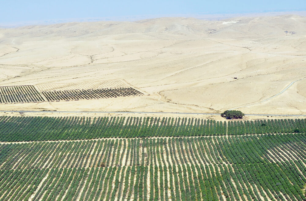
As we can observe in today’s world, agriculture is possible even in desserts. How can we justify this statement?
-
AGRICULTURE IN DESERTS Agriculture in deserts involves overcoming extreme conditions such as high temperature, poor soil quality etc...and utilizing advanced methods and techniques to cultivate crops. Countries like Israel and United Arab Emirates (UAE) are main examRead more
AGRICULTURE IN DESERTS
Agriculture in deserts involves overcoming extreme conditions such as high temperature, poor soil quality etc…and utilizing advanced methods and techniques to cultivate crops. Countries like Israel and United Arab Emirates (UAE) are main examples of successful agriculture projects. The high risk of cultivation is avoided by some methods such as drip irrigation, desalination, hydroponics, aeroponics, drought resistant crops, soil management, water harvesting, agroforestry and vertical farming.
DRIP IRRIGRATION:
By this method, water flows directly into the plant’s root and minimizes the water evaporation.
DROUGHT-RESISTANT CROPS:
Genetically modified crops are more resistant to drought that helps in cultivation with minimal amount of water.
AGROFORESTRY:
It combines the cultivation of crops and the management of trees and shrubs in same land. Soil improvement, water conservation, carbon sequestration are the benefits of agroforestry.
METHODS USED IN DIFFERENT COUNTRIES:
ISRAEL:
Israel is known for its agricultural techniques. Drip irrigation plays vital role in cultivating crops. Infact, this method is invented in Israel. They are using desalination and hydroponics widely.
UAE:
They invested heavily in transforming its arid area into agricultural area. They use vertical farming and hydroponics.
MOROCCO AND SAHEL REGION:
Farmers cultivate olive and argan trees with cereal crops and vegetables. Those long trees provide shade to those crops. Those fruits are providing extra economic benefits in Morocco.
Agroforestry restores degraded lands and improves soil quality and increases crop yields.
Countries like Israel, UAE successfully implemented many methods for enhancing food security and environmental resilience.
See less
El Nino-Southern Oscillation (ENSO) occurs due to a periodical variation in temperatures between the ocean and atmosphere in the east-central Equatorial Pacific. It has two phases: El Niño, characterized by warmer ocean temperatures, and La Niña, characterized by cooler ocean temperatures. It signifRead more
El Nino-Southern Oscillation (ENSO) occurs due to a periodical variation in temperatures between the ocean and atmosphere in the east-central Equatorial Pacific. It has two phases: El Niño, characterized by warmer ocean temperatures, and La Niña, characterized by cooler ocean temperatures. It significantly influences weather patterns globally, including the Indian monsoon system.
Relationship between ENSO Events and the Indian Monsoon
Impact of the Relationship between ENSO events and the Indian Monsoon
Way Ahead
Overall, the El Niño Southern Oscillation (ENSO) events have a profound impact on the Indian monsoon, affecting various sectors in India, including agriculture, biodiversity, and health. Adopting these strategies, India can pave a forward-thinking path in managing the impacts of ENSO events on its monsoonal patterns, focusing on sustainability and resilience in various sectors.
See less