In what ways does geomorphology influence urban land-use planning and environmental regulations?
Formation of Soil: Working Instructions Soil creation might be the most scientific artistic process involving the following factors and steps. 1. Weathering: 1.1. Physical Weathering – This involves the wearing out or breaking of rocks by external forces such as extremes of heat sun or cold water icRead more
Formation of Soil: Working Instructions
Soil creation might be the most scientific artistic process involving the following factors and steps.
1. Weathering:
1.1. Physical Weathering – This involves the wearing out or breaking of rocks by external forces such as extremes of heat sun or cold water ice or even wind
1.2. Chemical Weathering: In these weathering types, the molecular structures of rock minerals dissolved in water, air and other substances convert to simpler structures
1.3. Biological Weathering: This is the weathering process that is influenced by the action of living organisms like plants, animals and even microorganisms in performing both physical and chemical weathering.
2. Accumulation of Organic Material:
Plant and animal remains are incorporated at the surface.
Organic matter is transformed by the action of microorganisms producing a dark, rich, hummus material.
3. Leaching
Water penetrates the soil and carries the dissolved materials further into the soil profile.
This can leach nutrients from the upper part, but actually enriches the lower part.
4. Illuviation
Carriage of dissolved material by water and subsequent deposition in the lower levels of soil.
This process is responsible for the layering of soil profiles.
5. Development of Soil Profile
6. Development of Soil Profile
As years go by, distinct stratification of soils occurs and these include the following,
O Horizon – Tthese are areas mainly vegetated which contain soil composition made up of dead plants and animals decomposing and recycling
A Horizon – This is the thin upper crust, the top layer of soil ordure comprising of both organic and inorganic constituents.
B Horizon – This refers to the subsoil, a layer that is rich in minerals only.
C Horizon: This is the raw, unweathered deposit that is the immediate precursor of soil.
R Horizon: Refers to weathered rock or the soil parent material which has not weathered.
6. Time:
This process of soil formation occurs over thousands of years.
Climate, topography, and living organisms can all affect the rate at which soil is formed. Grasping the sequence of events enables one to comprehend the complexity that is involved in the processes of soil formation and supporting life.
See less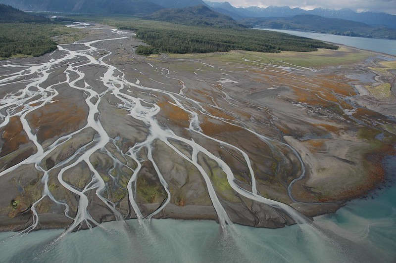

Geomorphology plays a vital role in shaping environmental policies and guiding land-use planning in urban areas. By understanding the physical landscape, planners and policymakers can make informed decisions that mitigate risks, enhance sustainability, and optimize land use. 1. Understanding NaturalRead more
Geomorphology plays a vital role in shaping environmental policies and guiding land-use planning in urban areas. By understanding the physical landscape, planners and policymakers can make informed decisions that mitigate risks, enhance sustainability, and optimize land use.
1. Understanding Natural Hazards
Geomorphological studies provide insights into natural hazards such as floods, landslides, and earthquakes. Identifying vulnerable areas helps in formulating policies that prioritize disaster risk reduction.
For example, in California, urban planners use geomorphological data to assess flood risks associated with riverbanks and coastal areas. The 2017 Santa Barbara mudslides demonstrated the importance of such assessments, leading to stricter zoning regulations in landslide-prone regions.
2. Groundwater Management
Geomorphology informs groundwater management strategies by identifying aquifer locations and recharge areas. Understanding the interactions between surface water and groundwater systems is crucial for sustainable water use.
In Ahmedabad, India, planners have integrated geomorphological studies to protect recharge zones and manage urban expansion. This is essential for maintaining groundwater levels in a rapidly urbanizing city, particularly during drought periods.
3. Soil Stability and Land Suitability
Assessing soil types and stability through geomorphological analysis is critical for determining land suitability for construction and agriculture. Areas with unstable soils are often deemed unsuitable for heavy construction.
The 2010 earthquake in Haiti underscored the need for robust land-use policies based on geomorphological assessments. Urban planning efforts in the aftermath emphasized avoiding construction in vulnerable zones and adopting building codes suited to local geological conditions.
4. Environmental Sustainability
Geomorphological insights help promote sustainable land use by identifying areas suitable for conservation, recreation, and development. Recognizing the relationship between landforms and ecosystems allows for the preservation of natural resources.
For instance, the Green Infrastructure Initiative in New York City incorporates geomorphological principles to enhance stormwater management and promote urban biodiversity. Strategies such as creating green roofs and restoring wetlands are informed by an understanding of local topography and hydrology.
5. Infrastructure Development and Maintenance
Geomorphology is essential for planning infrastructure such as roads, bridges, and drainage systems. By analyzing landforms and sediment transport, planners can design resilient infrastructure that minimizes environmental impact.
The River Thames flood management plan in London incorporates geomorphological assessments to design effective flood defenses. After severe flooding events, planners have utilized geomorphological data to retrofit and adapt infrastructure to handle increased rainfall and rising sea levels.
6. Climate Change Adaptation
As climate change poses new challenges, geomorphology aids in developing adaptive strategies for urban planning. Understanding how landscapes respond to climate variability informs policies for resilient urban development.
In cities like Miami, where rising sea levels threaten urban areas, geomorphological studies are guiding the implementation of adaptive measures such as building seawalls and restoring natural wetlands to buffer against coastal flooding.
Conclusion
Geomorphology is instrumental in shaping environmental policies and guiding land-use planning in urban areas. By providing critical insights into natural hazards, groundwater management, soil stability, and sustainable practices, geomorphology helps create resilient and environmentally responsible urban environments. Integrating these insights into policy-making is essential for addressing the complex challenges posed by urbanization and climate change.
See less