Home/World Geography/Geophysical Phenomena/Page 2
Geophysical Phenomena
Share
Lost your password? Please enter your email address. You will receive a link and will create a new password via email.
Please briefly explain why you feel this question should be reported.
Please briefly explain why you feel this answer should be reported.
Please briefly explain why you feel this user should be reported.
What are volcanic landforms? Explain the different types of intrusive volcanic landforms with examples. (200 words)
Model Answer Volcanic Landforms Volcanic landforms are geographical features created by volcanic activity, classified into extrusive and intrusive types based on whether magma cools inside or outside the Earth's crust. Intrusive Volcanic Landforms Intrusive landforms are formed when magma cools andRead more
Model Answer
Volcanic Landforms
Volcanic landforms are geographical features created by volcanic activity, classified into extrusive and intrusive types based on whether magma cools inside or outside the Earth’s crust.
Intrusive Volcanic Landforms
Intrusive landforms are formed when magma cools and solidifies beneath the Earth’s surface. These include various features:
These intrusive landforms are primarily found in areas like the Deccan Plateau.
See lessDiscuss the beneficial environmental effects of cyclones on ecosystems and geographical regions. (200 words)
Model Answer Cyclones, despite their destructive power, have several beneficial environmental effects that contribute to ecosystem balance and the well-being of geographical regions. 1. Rainfall in Drought-Prone Areas Tropical cyclones are efficient at generating rainfall, which can relieve droughtRead more
Model Answer
Cyclones, despite their destructive power, have several beneficial environmental effects that contribute to ecosystem balance and the well-being of geographical regions.
1. Rainfall in Drought-Prone Areas
Tropical cyclones are efficient at generating rainfall, which can relieve drought conditions. For example, Tropical Storm Debby helped eliminate a drought in the southern United States, bringing much-needed water to parched areas.
2. Red Tide and Bacterial Disruption
Cyclones break up harmful bacteria and red tide through strong winds and waves that mix ocean waters. This oxygenates the surface waters, enabling marine life to return. A notable example is the disruption of red tide along the Gulf Coast of the USA.
3. Global Heat Balance
Cyclones help regulate the Earth’s climate by moving warm tropical air to mid-latitudes and polar regions, contributing to the global heat balance. After Hurricane Blas, cooler waters were left behind in the Eastern Pacific, stabilizing the region’s temperature.
4. Climate Change Mitigation and Mangrove Growth
Cyclones also enhance the growth of mangroves by providing more nutrients and freshwater, aiding carbon sequestration. In India, tropical storms have positively impacted mangrove ecosystems by boosting their ability to fix carbon dioxide.
5. Replenishment of Inland Plant Life
Cyclonic winds and rainfall disperse seeds and nutrients inland, facilitating plant regeneration. This supports biodiversity and aids in restoring ecosystems disturbed by urbanization. For instance, hurricanes have contributed to the growth of tropical hardwood hammocks in South Florida.
6. Recharge of Groundwater Aquifers
The intense rainfall from cyclones can recharge groundwater aquifers in arid regions. Cyclones have helped replenish aquifers in areas like Chamarajanagar district of Karnataka, India.
7. Ecological Succession
Cyclones reset ecosystems by defoliating mature trees, allowing sunlight to reach the understory. This fosters the growth of shade-intolerant species, contributing to ecological succession and biodiversity.
In conclusion, while cyclones can cause widespread damage, their ecological benefits are significant, fostering biodiversity, climate regulation, and resource replenishment across ecosystems.
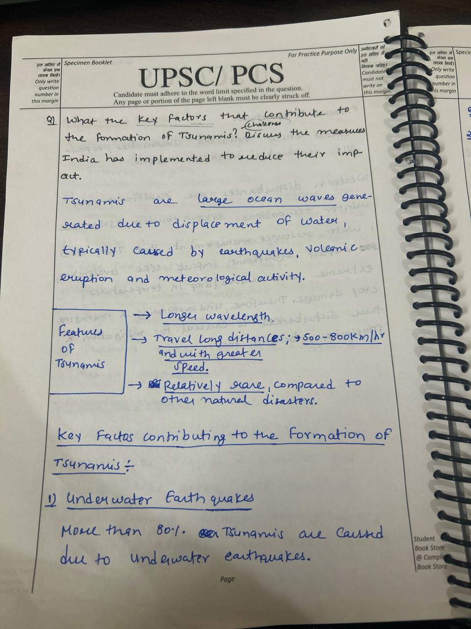
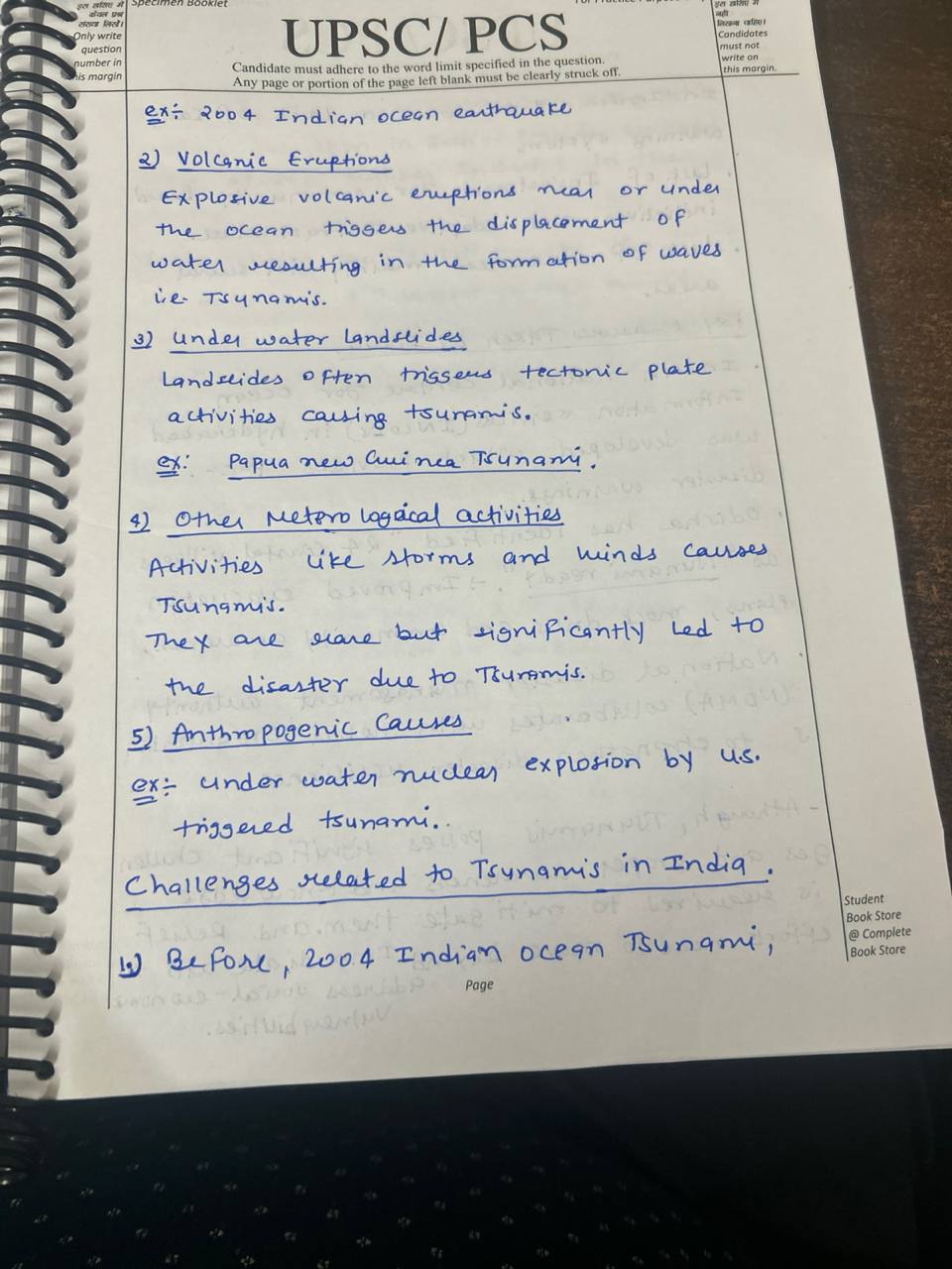
See lessWhat are the key factors that contribute to the formation of tsunamis? Discuss the measures India has implemented to reduce their impact. (200 words)

See lessDiscuss two widely accepted theories of origin of the earth. Elucidate the position of all planets within the solar system and write the important facts of the earth. [ UPSC PYQ 2024 ]
The two widely accepted theories of origin of the earth are: Nebular hypothesis The earth formed from a cloud of gas and dust, which collapsed under gravity, with the sun forming as it's center. Planetesimal hypotheses The earth formed from the accumulation of small Rocky bodies called planetesimal,Read more
The two widely accepted theories of origin of the earth are:
Nebular hypothesis
The earth formed from a cloud of gas and dust, which collapsed under gravity, with the sun forming as it’s center.
Planetesimal hypotheses
The earth formed from the accumulation of small Rocky bodies called planetesimal, which merged to form larger bodies, eventually becoming the earth.
Position of earth within the solar system
Mercury
Venus
Earth
Mars
Jupiter
Saturn
Uranus
Neptune
The earth is the third planet the sun
See lessDisaster Management
Impact of Cyclones on Coastal and Inland Regions Cyclones basically originate over the warm ocean waters and are normally associated with coastal destruction by means of storm surges and heavy rains brought about by strong winds. However, they do affect inland regions too, albeit through a series ofRead more
Impact of Cyclones on Coastal and Inland Regions
Cyclones basically originate over the warm ocean waters and are normally associated with coastal destruction by means of storm surges and heavy rains brought about by strong winds. However, they do affect inland regions too, albeit through a series of indirect and secondary effects:
1. Flooding and Landslides: Cyclones moving into the interior lose wind energy but often unleash torrents of rain, leading to riverine and flash floods. This tends easily to cause an overflow of rivers and reservoirs and floods inland urban and agricultural regions away from the coastal areas. In the high grounds, these rains cause landslides which augment the risks to both lives and property.
2. Disturbance of Basic Amenities: Regular power supply was interrupted; Telecoms, water and a number of transport networks were also rendered non-operational in many regions of the country due to the cyclones. The rural areas normally do not have resistant infrastructure; therefore, outages last for a long time and the delay leads to prolongation of suffering of human beings as well as economic losses.
3. Agricultural Losses: Inland agricultural belts are exposed to strong winds and heavy rains that lead to crop and livestock losses, soil erosion, flooding, and direct damage to farmlands. Thus, it impacts food security, livelihood and the rural economy, especially in the peasants’, agricultural based economy.
4. Economic Impacts and Migration: They influence the unfavorable effects that are manifested in supply chain disruption and damaged infrastructure slow down the pace of economic activities in inland regions. In extreme cases, displacement of populations in affected areas can add to the stress in the urban centers as people move for shelter and to seek employment.
India’s Readiness to Natural Hazards
The NDMA and State Disaster Management Authorities have provided frameworks that have helped India prepare and prevent disaster for quite a while now, especially along the coasts with advance warning systems and evacuation plans, as well as shelters for cyclones. Inland places are nowhere close to being prepared though, as the issue lies in alerting populations in rural inland areas, that are left unaware and without resources to prepare. Inland infrastructure such as power, road connectivity, and water supply usually is not cyclone-resistant. The heavy storms disrupt the power supplies, road connectivity, and water supply systems usually which tend to get severely disrupted when heavy storms occur.
-Community Awareness and Training: Inland area disaster preparedness training and awareness programs are only conducted for vulnerable groups like farmers and rural communities, who also have very little knowledge of cyclone impacts.
See lessRecap India has progressed in terms of preparedness for cyclones but has much-needed improvements inside in inland disaster response systems, infrastructure resilience, and community awareness before ensuring much broader national preparedness.
What is the phenomenon of “cloudbursts” ? Explain [ 150 words ]
Introduction A cloudburst is an intense and sudden rainfall event, typically localized to a small area, resulting in heavy downpours within a short period. The rainfall rate during a cloudburst often exceeds 100 mm per hour, sometimes causing flash floods and landslides, especially in hilly or mountRead more
Introduction
A cloudburst is an intense and sudden rainfall event, typically localized to a small area, resulting in heavy downpours within a short period. The rainfall rate during a cloudburst often exceeds 100 mm per hour, sometimes causing flash floods and landslides, especially in hilly or mountainous regions.
Body:
Mechanism of Cloudbursts: Cloudbursts occur when warm, moist air rapidly rises due to convection. As the air ascends, it cools, and the moisture condenses to form clouds. In certain conditions, particularly in regions with steep topography, the clouds are unable to release moisture gradually, leading to the sudden and concentrated release of rain.
Factors contributing to cloudbursts include:
Orographic Lift: In mountainous areas, air masses are forced upwards when they encounter hills or mountains. This increases condensation and can lead to the rapid release of rain.
E.g. Leh cloudburst in 2010
Temperature Differences: Sharp contrasts in temperature can lead to strong upward air currents, which trap moisture in the clouds, eventually leading to a cloudburst.
E.g. In Leh, Ladakh (2022), a cloudburst occurred due to a temperature-induced thunderstorm.
Localized Thunderstorms: Thunderstorms that develop due to intense heating can also trigger cloudbursts, with localized areas experiencing intense downpours.
E.g. In July 2021, a cloudburst near Amarnath Cave in Jammu and Kashmir
Effects of Cloudbursts:
Conclusion
Cloudbursts have become a significant concern in the Indian subcontinent, due to changing climate patterns and increasing human habitation in vulnerable areas and there is a need for robust urban planning and sustainable infrastructure development strategies to minimize damage.
See lessDiscuss the Process of soil formation [ 5 marks & 150 words ] UPSC 2024 PYQ
Soil formation is a continuous and complex process that involves several factors working together over time. The key processes involved are: 1. Weathering of Parent Material: Soil formation begins with the weathering of rocks (parent material) through physical, chemical, and biological processes. PhRead more
Soil formation is a continuous and complex process that involves several factors working together over time. The key processes involved are:
1. Weathering of Parent Material:
Soil formation begins with the weathering of rocks (parent material) through physical, chemical, and biological processes. Physical weathering breaks rocks into smaller pieces, while chemical weathering alters minerals, and biological weathering involves the action of organisms like plants and microorganisms.
2. Climate Influence:
Climate, particularly temperature and rainfall, plays a significant role in soil formation. High rainfall accelerates weathering and leaching, while temperature influences the rate of chemical reactions. In hot and wet climates, soils tend to be more weathered and leached.
3. Organisms:
Plants, animals, and microorganisms contribute organic matter that enriches the soil, influencing its texture, structure, and fertility. Decomposed organic material forms humus, which improves soil moisture retention and nutrient availability.
4. Topography:
The shape and slope of the land affect water drainage and erosion, influencing soil development. Steep slopes may lead to soil erosion, while flat areas accumulate soil.
5. Time:
Over long periods, soils evolve, and different horizons (layers) develop, contributing to the soil’s profile and fertility.
This process results in a variety of soil types with unique characteristics based on these influencing factors.
See lessGeography
The geosyncline model postulated by German geologist Leopold Kober in 1921 is summarized below: It should be mentioned that Kober, unlike one of his contemporaries Suess who focused the attention to tectonic forces, believed that geosynclines are the extensive elongated depositional troughs, which aRead more
The geosyncline model postulated by German geologist Leopold Kober in 1921 is summarized below:
It should be mentioned that Kober, unlike one of his contemporaries Suess who focused the attention to tectonic forces, believed that geosynclines are the extensive elongated depositional troughs, which are very long in the process of sinking through earth’s crust as extended periods of geological time are concerned. They are bordered by comparably stable continental crust blocks. They are bounded by relatively stable continental lithosphere domains.
Thick sequences of sediments eroded from adjacent land areas are formed as the geosyncline progressively deepens. The greatest thickness of sediment is deposited in the geosynclinical region reaching its central part.
Finally, the load of the overlying sedimentary rocks precipitates the geosyncline down into the asthenosphere (the plastic layer beneath the earth’s crust). This begins the mountain making processes by folding and faulting of the subsequent layers of sedimentary rocks.
General subsidence creates a condition favorable for the accumulation of further, superimposed layers of sediment on deformed strata. Therefore, such cycles as sedimentation subsidence and deformation can cover hundreds of millions of years.
Finally, if ground conditions are suitable, the geosyncline might be squeezed, folded, and uplifted in the mountainous belt. These latter ones are part of continental crust which was initially evolved from seabed sediments. The first ones can also be at deep rock that has been eroded.
Kober regarded the Geosyncline idea as an explanation for sedimentary and tectonic history of many mountain systems and plates. Information about his contributor may be reported in historical context of the early twentieth century geology preceding the theory of plates.
Thus, Kober’s geosyncline model was long trending basins wherein very thick marine sediments had prograded and these were afterward folded and uplifted into mountain chains through subsidence and crust shortening processes spanning large periods of time.
See lessHow are Volcano, Earthquake and Tsunami are related to each other? Highlight all the possible causes of volcanic eruptions.(UPPSC 2018)
Volcano , tsunami , earthquakes there ar three terms different thinks we discuss following Volcano - volcano is cindar cones , shield volcano ,composite volcano , there are major types of volcano . Volcano is a one of the highly fluid liquid material ..it is very harmful to human disaster life . eRead more
Volcano , tsunami , earthquakes there ar three terms different thinks we discuss following
Volcano – volcano is cindar cones , shield volcano ,composite volcano , there are major types of volcano .
Volcano is a one of the highly fluid liquid material ..it is very harmful to human disaster life . extinct volcano, active volcano ,endegeree volcano
Simply term means volcano is main term of geography.. Come from term god of fire vulcan , mam fire , it is mediterranean sea , ring of fire
India has many volcano area ex , barren island , north east and himalaya has earthquakes area but not volcano present there…besalt rocks main of the
See lessHow do historical volcanic events inform modern disaster response strategies?
Historical volcanic events provide invaluable insights that shape contemporary disaster response strategies. By analyzing past eruptions, scientists and policymakers can develop better preparedness plans, enhance community resilience, and implement effective mitigation measures. Here’s an analysis oRead more
Historical volcanic events provide invaluable insights that shape contemporary disaster response strategies. By analyzing past eruptions, scientists and policymakers can develop better preparedness plans, enhance community resilience, and implement effective mitigation measures. Here’s an analysis of how historical events inform modern strategies, supported by recent examples.
1. Lessons Learned from Past Eruptions
A. Understanding Eruption Patterns
B. Community Preparedness
2. Improving Monitoring and Early Warning Systems
A. Enhanced Technologies
B. Public Warning Systems
3. Community Engagement and Education
A. Risk Communication
B. Involvement of Local Stakeholders
4. Integrating Scientific Research and Policy Making
A. Data-Driven Decision Making
B. Funding and Resource Allocation
5. Global Collaboration and Research
A. International Learning
B. Research Initiatives
Conclusion
Historical volcanic events are crucial for shaping modern disaster response strategies. By analyzing past eruptions, communities can enhance preparedness, improve monitoring systems, and foster greater resilience. Recent examples illustrate the importance of integrating historical lessons into contemporary practices, ensuring that societies are better equipped to handle future volcanic threats. This continuous learning process is vital for safeguarding lives and minimizing the socio-economic impacts of volcanic eruptions.
See less