


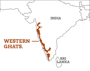
The Western Ghats, a mountain range running parallel to the western coast of India, significantly influence the region's climate and are recognized globally as a biodiversity hotspot. Stretching over 1,600 kilometers, the range impacts weather patterns and harbors an immense variety of flora and fauRead more
The Western Ghats, a mountain range running parallel to the western coast of India, significantly influence the region’s climate and are recognized globally as a biodiversity hotspot. Stretching over 1,600 kilometers, the range impacts weather patterns and harbors an immense variety of flora and fauna, underscoring its ecological importance.
Encompassing the states of Gujarat, Maharashtra, Goa, Karnataka, Kerala, and Tamil Nadu, the Western Ghats are a critical ecological treasure. Protecting this range is vital for maintaining India’s climatic stability and preserving its unparalleled biodiversity.
The Western Ghats play a crucial role in India’s climate by intercepting the southwest monsoon winds, causing heavy rainfall on the western slopes and creating a rain shadow effect on the eastern side. This rainfall supports lush evergreen forests and a variety of ecosystems, crucial for the water supply and agriculture in peninsular India. Additionally, the Ghats moderate temperatures, creating a cooler and more humid environment in the regions they traverse.
As a biodiversity hotspot, the Western Ghats are home to an extraordinary number of endemic species, with over 7,400 species of flowering plants, 139 mammal species, 508 bird species, 179 amphibian species, and numerous invertebrates. This rich biodiversity is attributed to the range’s diverse habitats, from tropical rainforests to montane forests, each supporting unique ecological communities. Conservation efforts are paramount due to threats from deforestation, habitat fragmentation, and climate change.
See less


Geospatial technology, such as Geographic Information Systems (GIS) and remote sensing, helps protect vulnerable ecosystems from climate change. Here's how: 1. Mapping and Monitoring: - Land Changes: Track deforestation and urban growth to manage land use better. - Biodiversity: Identify areas richRead more
Geospatial technology, such as Geographic Information Systems (GIS) and remote sensing, helps protect vulnerable ecosystems from climate change.
Here’s how:
1. Mapping and Monitoring:
– Land Changes: Track deforestation and urban growth to manage land use better.
– Biodiversity: Identify areas rich in species to focus conservation efforts.
2. Climate Prediction:
– Weather: Predict weather patterns and extreme events to prepare ecosystems.
– Sea-Level Rise: Model rising sea levels to protect coastal areas.
3. Disaster Management:
– Floods and Droughts: Monitor these events to provide early warnings.
– Wildfires: Assess fire risk and monitor active fires to safeguard forests.
4. Conservation Planning:
– Habitat Restoration: Find the best areas for reforestation and habitat restoration.
– Protected Areas: Help manage protected areas by providing detailed habitat maps.
5. Resource Management:
– Water: Monitor water resources to ensure sustainable use.
– Agriculture: Optimize farming practices to reduce environmental impact.
6. Community Engagement:
– Public Awareness: Use maps to educate people about climate impacts.
– Local Involvement: Involve communities in mapping efforts to include local knowledge.
7. Urban Planning:
See less– Sustainable Cities: Plan green spaces and climate-resilient infrastructure to protect urban environments.