Home/World Geography/World’s Physical Geography/Page 4
World’s Physical Geography
Share
Lost your password? Please enter your email address. You will receive a link and will create a new password via email.
Please briefly explain why you feel this question should be reported.
Please briefly explain why you feel this answer should be reported.
Please briefly explain why you feel this user should be reported.
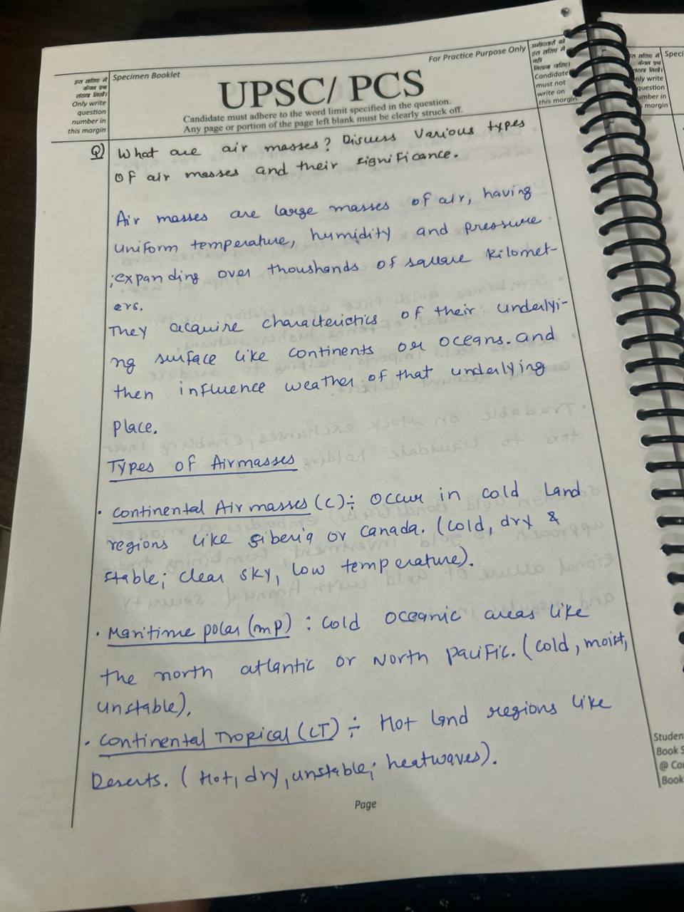
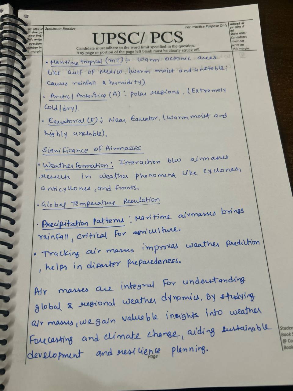
What are air masses? Discuss the various types of air masses and their significance. (200 words)
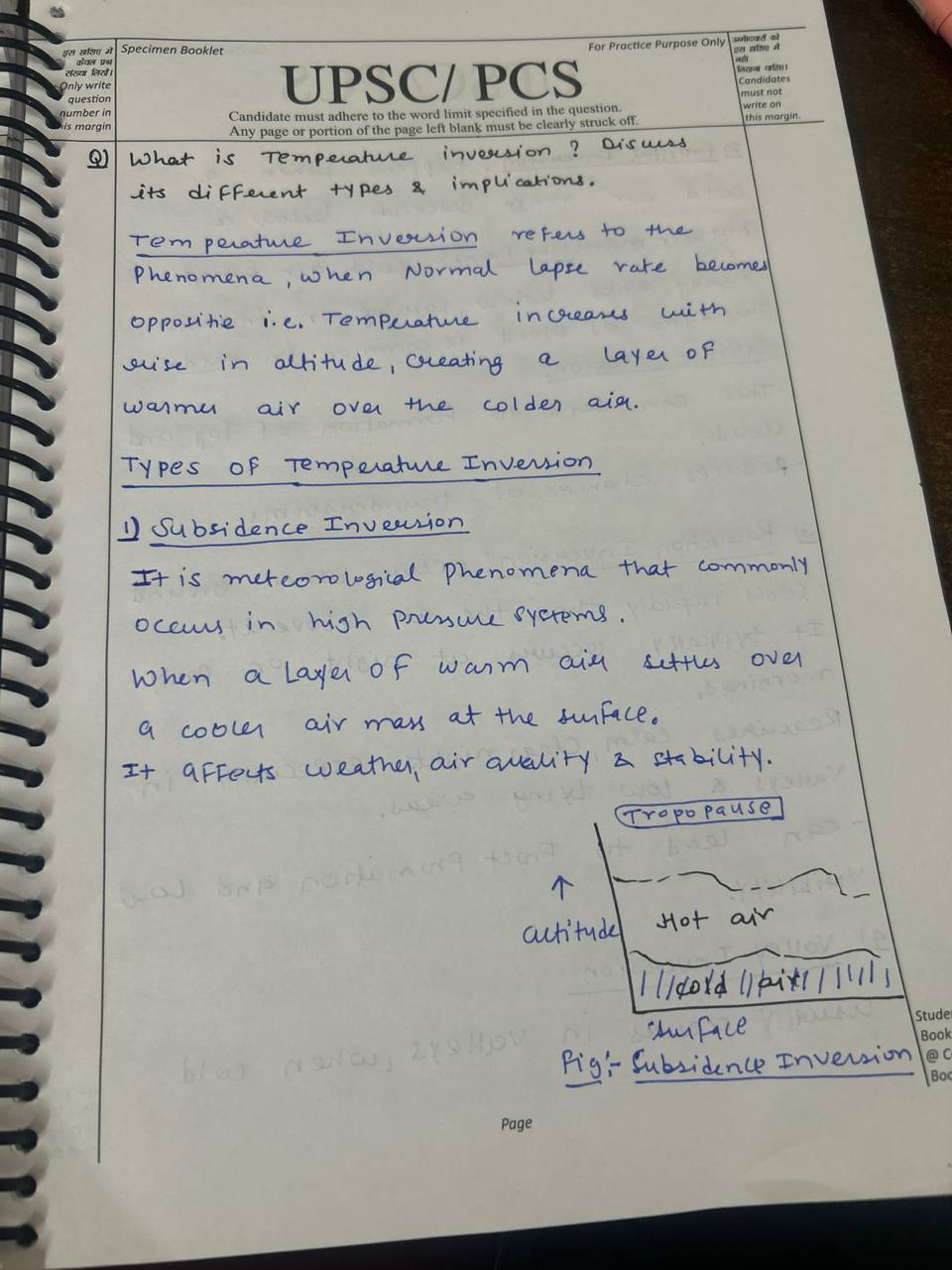
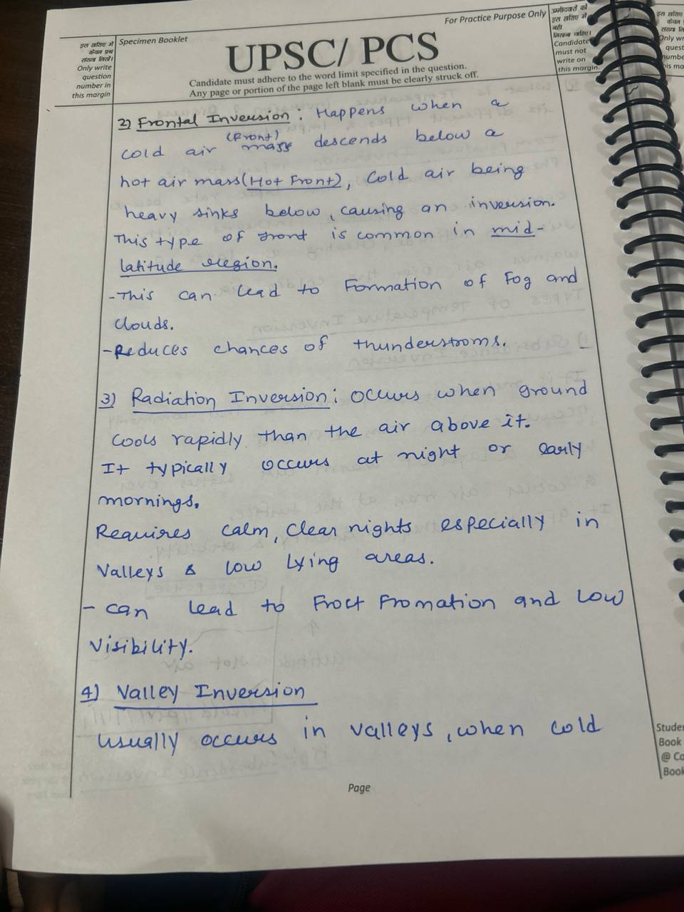
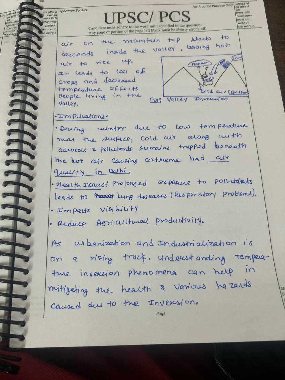
See lessWhat is temperature inversion? Discuss its different types and their implications. (200 words)
See less"Age Structure and Fertility Rates in Developing Countries"
Age Structure and Fertility Rates: Managing Demographic Change in Developing Nations Of all the demography characteristics, age and fertility influencing population development in developing nations are crucial factors. Age Structure: Youth Bulge: They are a resource that if given a large populationRead more
Age Structure and Fertility Rates: Managing Demographic Change in Developing Nations
Of all the demography characteristics, age and fertility influencing population development in developing nations are crucial factors.
Age Structure:
Youth Bulge: They are a resource that if given a large population of young people can cause fast overpopulation therefore a lot of demands on the available resources and development infrastructure.
-Aging Population: Few births you have correspond with higher level of dependency of the aged as people age thus implying a higher number of the aged and those who will be being supported by working population.
Demographic Dividend: The time when a majority of the population is in the working population. In such a case economic growth and development is possible if there is investment in education, health and employment.
Fertility Rates:
High Fertility Rates: Problem of providing basic needs such education, health and employment in areas of rapid population growth due to high fertility rates will arise.
One could slow the rate of growth of the population and leave it in its old age. It has advantages and disadvantages – on one hand less resources are being used, on the other hand – economic issues may arise.
It is influenced by fertility rate meaning it is associated with several effects that a country can go through on the social, economic and environmental front. For instance, high fertility population that happens within the youthful population may find it difficult to facilitate education and health facility while the aged people require much investment on the social security and health services.
See lessDiscuss two widely accepted theories of origin of the earth. Elucidate the position of all planets within the solar system and write the important facts of the earth. [ UPSC PYQ 2024 ]
The two widely accepted theories of origin of the earth are: Nebular hypothesis The earth formed from a cloud of gas and dust, which collapsed under gravity, with the sun forming as it's center. Planetesimal hypotheses The earth formed from the accumulation of small Rocky bodies called planetesimal,Read more
The two widely accepted theories of origin of the earth are:
Nebular hypothesis
The earth formed from a cloud of gas and dust, which collapsed under gravity, with the sun forming as it’s center.
Planetesimal hypotheses
The earth formed from the accumulation of small Rocky bodies called planetesimal, which merged to form larger bodies, eventually becoming the earth.
Position of earth within the solar system
Mercury
Venus
Earth
Mars
Jupiter
Saturn
Uranus
Neptune
The earth is the third planet the sun
See lessDiscuss the Importance of a mineral resource for the development of a nation ?
Mineral resources play a crucial role in the development of a nation, as they are foundational to industrial growth, economic stability, and technological advancement. Minerals like coal, iron, copper, and bauxite are essential for building infrastructure, producing energy, and manufacturing a wideRead more
Mineral resources play a crucial role in the development of a nation, as they are foundational to industrial growth, economic stability, and technological advancement. Minerals like coal, iron, copper, and bauxite are essential for building infrastructure, producing energy, and manufacturing a wide range of goods, from machinery to electronics. They enable the construction of transportation networks, buildings, and other key infrastructure, which forms the backbone of a modern economy.
One of the primary reasons mineral resources are vital is that they provide raw materials for heavy industries, which drive economic growth and create employment opportunities. For example, iron ore is crucial for the steel industry, which supports construction, automotive, and numerous other sectors. Similarly, energy minerals such as coal, natural gas, and uranium are fundamental for power generation, which fuels industries, homes, and public infrastructure.
Furthermore, mineral exports can generate significant revenue, helping nations improve their foreign exchange reserves and balance of trade. Developing a strong mineral extraction industry can reduce a nation’s reliance on imports, enhancing its economic independence and resilience.
In addition, minerals are central to advancing technology and innovation, particularly in renewable energy and electronics. Minerals like lithium, cobalt, and rare earth elements are essential for batteries, solar panels, and other modern technologies that support sustainable development.
See lessOcean Currents
Ocean currents are primarily driven by several key factors :- Wind Patterns : The wind drape the sea surface water in the direction of its motion due to frictional drag and this leads to oceanic current generated. For example, In tropical areas the oceanic current moves from east to west under the iRead more
Ocean currents are primarily driven by several key factors :-
Current of the Atlantic Oceans :
The Ocean Current themselves play a notable role in determining the regional currents, navigation, fishing patterns and oceanic ecosystems.
See lessDiscuss the Process of soil formation [ 5 marks & 150 words ] UPSC 2024 PYQ
Soil formation is a continuous and complex process that involves several factors working together over time. The key processes involved are: 1. Weathering of Parent Material: Soil formation begins with the weathering of rocks (parent material) through physical, chemical, and biological processes. PhRead more
Soil formation is a continuous and complex process that involves several factors working together over time. The key processes involved are:
1. Weathering of Parent Material:
Soil formation begins with the weathering of rocks (parent material) through physical, chemical, and biological processes. Physical weathering breaks rocks into smaller pieces, while chemical weathering alters minerals, and biological weathering involves the action of organisms like plants and microorganisms.
2. Climate Influence:
Climate, particularly temperature and rainfall, plays a significant role in soil formation. High rainfall accelerates weathering and leaching, while temperature influences the rate of chemical reactions. In hot and wet climates, soils tend to be more weathered and leached.
3. Organisms:
Plants, animals, and microorganisms contribute organic matter that enriches the soil, influencing its texture, structure, and fertility. Decomposed organic material forms humus, which improves soil moisture retention and nutrient availability.
4. Topography:
The shape and slope of the land affect water drainage and erosion, influencing soil development. Steep slopes may lead to soil erosion, while flat areas accumulate soil.
5. Time:
Over long periods, soils evolve, and different horizons (layers) develop, contributing to the soil’s profile and fertility.
This process results in a variety of soil types with unique characteristics based on these influencing factors.
See lessDescribe the landforms formed by wind erosion and depositional works. (200 Words) [UPPSC 2019]
Landforms are natural geological features or shapes that make up the earth's surface including mountains, hills, valleys, plateaus, plains, canyons and other visible landscape elements formed by erosion, deposition and tectonic processes. Landforms formed by wind erosion also known as aeolian erosioRead more
Landforms are natural geological features or shapes that make up the earth’s surface including mountains, hills, valleys, plateaus, plains, canyons and other visible landscape elements formed by erosion, deposition and tectonic processes.
Landforms formed by wind erosion also known as aeolian erosion include deflation basins, blowouts, yardangs and mushroom rocks. Wind abrasion creates unique features like ventifacts and dreikanter. Erosion by wind also forms caves, arches and peculiar rock formations in arid and coastal regions, reshaping landscapes over time.
Landforms formed by Depositional works –
Landforms provide vital ecosystem services, support biodiversity and offer resources like water, minerals and fertile soil, while also serving as recreational, tourism and cultural sites, sustaining human livelihoods and well being.
See lessGeography
The geosyncline model postulated by German geologist Leopold Kober in 1921 is summarized below: It should be mentioned that Kober, unlike one of his contemporaries Suess who focused the attention to tectonic forces, believed that geosynclines are the extensive elongated depositional troughs, which aRead more
The geosyncline model postulated by German geologist Leopold Kober in 1921 is summarized below:
It should be mentioned that Kober, unlike one of his contemporaries Suess who focused the attention to tectonic forces, believed that geosynclines are the extensive elongated depositional troughs, which are very long in the process of sinking through earth’s crust as extended periods of geological time are concerned. They are bordered by comparably stable continental crust blocks. They are bounded by relatively stable continental lithosphere domains.
Thick sequences of sediments eroded from adjacent land areas are formed as the geosyncline progressively deepens. The greatest thickness of sediment is deposited in the geosynclinical region reaching its central part.
Finally, the load of the overlying sedimentary rocks precipitates the geosyncline down into the asthenosphere (the plastic layer beneath the earth’s crust). This begins the mountain making processes by folding and faulting of the subsequent layers of sedimentary rocks.
General subsidence creates a condition favorable for the accumulation of further, superimposed layers of sediment on deformed strata. Therefore, such cycles as sedimentation subsidence and deformation can cover hundreds of millions of years.
Finally, if ground conditions are suitable, the geosyncline might be squeezed, folded, and uplifted in the mountainous belt. These latter ones are part of continental crust which was initially evolved from seabed sediments. The first ones can also be at deep rock that has been eroded.
Kober regarded the Geosyncline idea as an explanation for sedimentary and tectonic history of many mountain systems and plates. Information about his contributor may be reported in historical context of the early twentieth century geology preceding the theory of plates.
Thus, Kober’s geosyncline model was long trending basins wherein very thick marine sediments had prograded and these were afterward folded and uplifted into mountain chains through subsidence and crust shortening processes spanning large periods of time.
See less