


Climate change significantly affects agriculture and food security in several ways. Rising temperatures, altered precipitation patterns, and increased frequency of extreme weather events like droughts, floods, and storms disrupt crop yields and livestock productivity. Impact on Crop Yields: Higher tRead more
Mains Answer Writing Latest Questions
How does this climate change affect agriculture and food security?

RekhaBegginer
-
Tectonic plates play a key role in shaping the Earth's surface, with various geological features such as - mountains, trenches, plateaus, etc. Classification of plate boundaries: 1. Constructive Plate Boundaries - Here two plates move away from each other, leading to the rise of magma from the mantlRead more
Tectonic plates play a key role in shaping the Earth’s surface, with various geological features such as – mountains, trenches, plateaus, etc.
Classification of plate boundaries:
1. Constructive Plate Boundaries – Here two plates move away from each other, leading to the rise of magma from the mantle and solidifying to form new crust like- mid-oceanic ridges, rift valleys, etc. E.g. – mid-Atlantic ridge.
The upwelling of magma when the plates move apart leads to volcanism. Very low intensity earthquake occurs here when plates move apart.
2. Destructive Plate Boundaries– Here two plates move towards each other, leading to a collision when the denser plate is subducted below the lighter one. E.g.- the Himalayas formation.
Due to immense pressure and friction strong earthquakes are associated with destructive plates. Volcanism also can occur when the subducted plates melt to form magma and rise up.
3. Conservative plates Boundaries- In this case, the plates move past each other horizontally neither creating nor destroying. E.g.- the San Andreas fault in California.
The energy released by the sliding motions of plates can cause the ground to shake leading to massive earthquakes. As there is no subduction or release of magma no volcanic activity takes place here.
See less

TeamSupreme
Explain how glaciers shaped the landforms in high alpine regions. (200 Words) [UPPSC 2020]
-
Role of Glaciers in Shaping Landforms in High Mountain Areas Glacial Erosion Glaciers are powerful agents of erosion in high mountain areas. As glaciers advance and retreat, they erode the landscape through two main processes: Plucking: This occurs when glaciers remove rock from the valley floor andRead more
Role of Glaciers in Shaping Landforms in High Mountain Areas
Glacial Erosion
Glaciers are powerful agents of erosion in high mountain areas. As glaciers advance and retreat, they erode the landscape through two main processes:
- Plucking: This occurs when glaciers remove rock from the valley floor and sides, as ice picks up and carries fragments. For example, the Yosemite Valley in the Sierra Nevada was carved through plucking by glaciers during the last Ice Age.
- Abrasion: This happens when the glacier’s movement grinds down the rock surface beneath it, causing scratches and polishing. The Himalayan range has numerous features shaped by abrasion, including the deep, U-shaped valleys.
Landforms Created by Glaciers
- U-Shaped Valleys: Unlike V-shaped valleys formed by rivers, glaciers carve out U-shaped valleys with steep sides and flat bottoms. The Glacier National Park in Montana showcases many such valleys, formed by glacial action.
- Cirques: These are amphitheater-like depressions formed at the head of a glacier. The Andes Mountains feature numerous cirques, including the prominent Huascarán Cirque in Peru.
- Aretes and Horns: Aretes are sharp ridges between two glacial valleys, while horns are pointed peaks formed when several glaciers erode a mountain from multiple sides. The Matterhorn in the Alps is a classic example of a horn.
- Moraines: Glaciers deposit debris as moraines along their sides and ends. These formations include terminal moraines at the glacier’s end and lateral moraines along its sides. The Patagonian Ice Field in South America features extensive morainal deposits.
- Glacial Lakes: Meltwater from glaciers can form glacial lakes in depressions. The Rila Lakes in Bulgaria are a result of glacial activity, creating stunning high-altitude lake systems.
Recent Examples
- The 2015 Nepal Earthquake caused significant glacial melt and landslides in the Himalayas, highlighting the dynamic nature of glacial landforms.
- The melting of glaciers in the Alps due to climate change has exposed previously hidden landforms and altered the landscape significantly.
In summary, glaciers play a crucial role in shaping high mountain landforms through processes of erosion and deposition, creating features such as U-shaped valleys, cirques, aretes, horns, and moraines. These processes continue to shape landscapes, influenced by both natural forces and climatic changes.
See less


Smitha KrishnanBegginer
Roadmap for Answer Writing 1. Introduction: Contextualizing the Search Objective: Introduce the topic by highlighting the significance of the search for extraterrestrial life and the interest it generates. Key Points to Include: Humanity’s long-standing fascination with extraterrestrial life. Recent advancements in technology and space science ...
-

Model Answer Current Efforts in the Search for Extraterrestrial Life The quest to find extraterrestrial life has intensified in recent years, driven by technological advances and space exploration missions. Some of the primary efforts include: Exoplanet Surveys: Space telescopes like NASA's Kepler aRead more
Model Answer
Current Efforts in the Search for Extraterrestrial Life
The quest to find extraterrestrial life has intensified in recent years, driven by technological advances and space exploration missions. Some of the primary efforts include:
- Exoplanet Surveys: Space telescopes like NASA’s Kepler and TESS have revolutionized the search for habitable planets. These missions have discovered thousands of exoplanets, some located in the “habitable zone” where conditions might support liquid water, a key indicator of potential life.
- Planetary Missions: Agencies like NASA and ESA are actively exploring planets and moons within our solar system. The Mars rovers, Curiosity and Perseverance, are searching for signs of past or present life on Mars, while missions like ESA’s JUICE are investigating icy moons around Jupiter and Saturn for conditions favorable to life.
- SETI: The Search for Extraterrestrial Intelligence (SETI) uses radio telescopes to scan for signals from intelligent alien civilizations. Researchers analyze vast amounts of data looking for artificial signals that could indicate extraterrestrial communication.
- LBTI Instrument: The Large Binocular Telescope Interferometer (LBTI) in Arizona, funded by NASA, is another tool for studying exoplanets and their potential to host life, focusing on gathering high-resolution data from distant planets.
Challenges in the Search for Extraterrestrial Life
Despite significant progress, the search for extraterrestrial life faces several challenges:
- Distance and Inaccessibility: The enormous distances between stars and planets make direct exploration incredibly difficult. Current technology lacks the capability for fast travel or sample-return missions to distant exoplanets.
- Technological Limitations: Current instruments are limited in their ability to detect signs of life, particularly on distant exoplanets. The sensitivity of instruments needs improvement to identify biosignatures accurately.
- Defining Life: Life on Earth serves as the benchmark for detecting extraterrestrial life. However, life elsewhere might not follow the same patterns, making it hard to define what to look for in other worlds.
- Costs and False Positives: Missions to gather samples or explore distant bodies are costly and complex. Moreover, distinguishing between actual signs of life and natural phenomena is challenging, risking false positives or negatives.
In conclusion, while the search for extraterrestrial life is filled with challenges, ongoing advancements in space technology and collaboration are improving our chances of success.
See less
Smitha KrishnanBegginer
Roadmap for Answer Writing Introduction Begin with the definition of a biome. Mention that biomes are large ecological regions characterized by specific climatic conditions, plant life, and animal species. List the major biomes: Forest, Grassland, Desert, Tundra, and Aquatic (Freshwater and Marine). Body: 1. Forest ...
-
Model Answer Introduction Biomes are large ecological areas defined by their climate, vegetation, and wildlife. Earth is home to a variety of biomes, each with unique environmental characteristics. The major biomes include forests, grasslands, deserts, tundras, and aquatic biomes, each of which inflRead more
Model Answer
Introduction
Biomes are large ecological areas defined by their climate, vegetation, and wildlife. Earth is home to a variety of biomes, each with unique environmental characteristics. The major biomes include forests, grasslands, deserts, tundras, and aquatic biomes, each of which influences the types of organisms that can live there.
Forest Biomes
- Tropical Rainforest:
- Climate: High temperatures and year-round rainfall with little seasonal variation.
- Flora: Dense vegetation with tall trees, vines, and epiphytes.
- Fauna: Rich biodiversity, including insects, birds, reptiles, and mammals. For example, Brazil’s tropical rainforests support various species like jaguars and toucans.
- Temperate Deciduous Forest:
- Climate: Moderate temperatures with four distinct seasons.
- Flora: Deciduous trees such as oak, maple, and beech.
- Fauna: Squirrels, deer, bears, and foxes.
- Taiga (Boreal Forest):
- Climate: Long, cold winters and short, mild summers.
- Flora: Coniferous trees like spruce and fir.
- Fauna: Moose, bears, wolves, and various bird species.
Desert Biome
- Climate: Low rainfall, extreme temperatures, and significant temperature variations.
- Flora: Cacti, succulents, and drought-resistant shrubs.
- Fauna: Animals like camels, reptiles, and small mammals that conserve water.
Grassland (Savannah) Biome
- Climate: Seasonal rainfall with distinct wet and dry seasons.
- Flora: Dominated by grasses, with scattered trees.
- Fauna: Herbivores like zebras, giraffes, and predators like lions.
Tundra Biome
- Climate: Very cold temperatures, strong winds, and low precipitation.
- Flora: Low-growing plants such as mosses and lichens.
- Fauna: Reindeer, polar bears, and migratory birds adapted to the harsh conditions.
Aquatic Biomes
- Freshwater Biome:
- Climate: Varies with regional climate patterns.
- Flora: Aquatic plants like water lilies and algae.
- Fauna: Fish, amphibians, and various bird species.
- Marine Biome:
- Climate: Influenced by ocean temperatures and currents.
- Flora: Phytoplankton, seaweed, and coral reefs in coastal areas.
- Fauna: Fish, whales, dolphins, sharks, and various invertebrates.
Conclusion
Each biome is distinguished by its unique climate, vegetation, and animal life. These differences have shaped the development of specialized flora and fauna, allowing species to adapt and thrive in their respective environments.
See less - Tropical Rainforest:

Ritu tyagiLearner
Distinguish between exogenic and endogenic processes involved in geomorphology. Stress the importance of weathering as well. (Answer in 200 words)
-
Answer: The endogenic and exogenic forces causing physical stresses and chemical actions on earth materials and bringing about changes in the configuration of the surface of the earth are known as geomorphic processes. While, diastrophism and volcanism are endogenic geomorphic processes, weathering,Read more
Answer: The endogenic and exogenic forces causing physical stresses and chemical actions on earth materials and bringing about changes in the configuration of the surface of the earth are known as geomorphic processes. While, diastrophism and volcanism are endogenic geomorphic processes, weathering, mass wasting, erosion and deposition are exogenic geomorphic processes. The differences between the two processes are as follows:
Parameter Endogenic Processes Exogenic Processes Location Inside the surface of the Earth. Outside the surface of the Earth. Driving Forces The energy emanating from within the earth, mostly by radioactivity, rotational and tidal friction, and primordial heat from the origin of the earth, is the main force behind endogenic geomorphic processes. The exogenic processes derive their energy from the atmosphere determined by the ultimate energy from the sun and also the gradients created by tectonic factors. Effects The energy due to geothermal gradients and heat flow from within induces diastrophism and volcanism in the lithosphere. Gravitational force acts upon all earth materials having a sloping surface and tends to produce movement of matter in a downslope direction. Nature Constructive forces as they create relief features on the surface of the Earth. Destructive forces result in destruction via weathering, denudation, and erosional processes. Examples Earthquakes, Volcanoes, etc. Wind, Rivers, Glaciers, etc. Significance of Weathering: Weathering is the action of elements of weather and climate over the earth’s materials. There are a number of processes within weathering that act either individually or together to affect the earth’s materials in order to reduce them to a fragmental state.
- Weathering processes are responsible for breaking down the rocks into smaller fragments and preparing the way for the formation of not only regolith and soils but also erosion and mass movements.
- Weathering is an important process in the formation of soils. Biodiversity depends upon vegetation, which in turn, is dependent upon the depth of weathering mantles.
- Weathering aids mass wasting, erosion, and reduction of relief. Also, changes in landforms are a consequence of erosion.
- Weathering of rocks and deposits helps in the enrichment and concentrations of certain valuable ores of iron, manganese, aluminum, copper, etc., which are of great importance to the national economy.
- Weathering processes are conditioned by many complex geological, climatic, topographic and vegetative factors.

Ritu tyagiLearner
List the ways in which flowing water has influenced the development of landforms. Explain in detail the different depositional characteristics of flowing water as well.(Answer in 200 words)
-
Answer: Running water is considered one of the most important geomorphic agents bringing about the degradation of the land surface. There are two components of running water. One is overland flow on the general land surface as a sheet and another is linear flow as streams and rivers in valleys. SignRead more
Answer: Running water is considered one of the most important geomorphic agents bringing about the degradation of the land surface. There are two components of running water. One is overland flow on the general land surface as a sheet and another is linear flow as streams and rivers in valleys. Significance of running water in the evolution of landforms:
- Most of the erosional landforms made by running water are associated with vigorous and youthful rivers flowing over steep gradients.
- With time, stream channels over steep gradients turn gentler due to continued erosion, and as a consequence, lose their velocity, facilitating active deposition.
- There may be depositional forms associated with streams flowing over steep slopes. But these phenomena will be on a small scale compared to those associated with rivers flowing over medium to gentle slopes.
- The gentler the river channels in gradient or slope, the greater the deposition. When the stream beds turn gentler due to continued erosion, downward cutting becomes less dominant lateral erosion of banks increases and as a consequence, the hills and valleys are reduced to plains.
- Overland flow causes sheet erosion. Depending upon irregularities of the land surface, the overland flow may concentrate into narrow to wide paths forming rills, gullies, and ultimately valleys.
Depositional Features of Running Water
Feature Characteristics Diagram Alluvial Fans Alluvial fans are formed when streams flowing from higher levels break into foot slope plains of low gradient. Normally very coarse load is carried by streams flowing over mountain slopes. This load becomes too heavy for the streams to be carried over gentler gradients and gets dumped and spread as a broad low to high cone-shaped deposit called an alluvial fan. 
Deltas Deltas are like alluvial fans but develop at a different location. The load carried by the rivers is dumped and spread into the sea. If this load is not carried away far into the sea or distributed along the coast, it spreads and accumulates as a low cone. Unlike in alluvial fans, the deposits making up deltas are well very sorted with clear stratification. 
Floodplains, Natural Levees and Point Bars Deposition develops a floodplain just as erosion makes valleys. Floodplain is a major landform of river deposition. Large-sized materials are deposited first when the stream channel breaks into a gentle slope. Thus, normally, fine-sized materials like sand, silt, and clay are carried by relatively slow-moving waters in gentler channels usually found in the plains and deposited over the bed and when the waters spill over the banks during flooding above the bed. Natural levees are found along the banks of large rivers. They are low, linear, and parallel ridges of coarse deposits along the banks of rivers, quite often cut into individual mounds. Point bars are also known as meander bars. They are found on the concave side of meanders of large rivers and are sediments deposited in a linear fashion by flowing waters along the bank. 
The study of running water in the evolution of landforms helps us understand and appreciate the diversity of landforms on the surface of the earth.
See less

Pranjal shekhBegginer
Talk about the ecological and economic importance of lakes after providing a brief history of the lakes created by Earth’s movement. (Answer in 250 words)
-
Lakes are defined as large areas of water bodies that occupy the hollows of the Earth's surface, are surrounded by land, and are not connected to the seas except by rivers or streams. Lakes can be formed due to various factors such as Earth's movement, glaciation, volcanic activity, erosion, depositRead more
Lakes are defined as large areas of water bodies that occupy the hollows of the Earth’s surface, are surrounded by land, and are not connected to the seas except by rivers or streams. Lakes can be formed due to various factors such as Earth’s movement, glaciation, volcanic activity, erosion, deposition, and human and biological activities.
The lakes formed due to Earth’s movements are as follows:
- Tectonic lakes:
- These lakes are formed when depressions in the Earth’s surface occur due to the sagging, warping, bending and fracturing of the Earth’s crust.
- Some examples of such lakes are Lake Titicaca in the Andes, Caspian Sea, Baikal Lake, Sea of Aral, and Wular Lake in India.
- Rift Valley lakes:
-
- Due to the faults in the Earth’s crust, rift valleys are formed by the sinking of land between two parallel faults.
- Examples of such lakes are the East African Rift Valley Lake extending from Zambia in Africa to Jordan in the Middle- East, Tanganyika, Malawi, Rudolf, Albert, Dead Sea, etc.
Human life is closely linked to the water bodies, and lakes are no different. They not only play a crucial role in the economic, social, and cultural life of people but are also a key link in our ecological system. Economic significance of lakes
- Means of communication: They are a cheap and convenient mode of transportation for bulk and heavy materials such as iron, coal, cement, etc. For example, the Great Lakes of North America and St. Lawrence waterways are used as the chief arteries of commerce.
- Industrial development: The development of all sectors is greatly influenced by the proximity to the lakes. For instance, the HOMES Districts in the USA near the Great Lakes, Wuhan in China near Lakes Poyang, etc.
- Water storage: They are used as water storage for the supply of water for human consumption and industrial purposes. For example, Lake Thirlmere supplies water to Manchester, Okhla Reservoir supplies water to Delhi, etc.
- Hydroelectric power generation: Lakes are a great source of water for clean and cheap hydel power generation. For example, Lake Erie and Lake Ontario in North America, Abu Bakar Dam in Malaysia, and Bhakra Nangal in India.
- Source of minerals: Lakes are a source of minerals such as common salts, rock salt, gypsum, Borax, etc., and have led to the development of chemical industries around them.
Ecological significance of lakes:
- Nutrient cycling: Lakes play a critical role in nutrient cycling through water, carbon, and nitrogen cycles.
- Regulation of water levels: During periods of heavy rainfall, lakes absorb the excess water and thus prevent flooding, while during the lean seasons, they release water to the rivers and maintain a steady flow. This ensures ecological flow and helps maintain the fragile ecosystem of rivers and related water bodies.
- Moderation of climate: Differential heating of deep and large water bodies helps moderate the climate of the surrounding regions. It also creates a conducive environment for rainfall.
- Conservation of species: Lakes play a critical role in conserving the ecosystem and its diversity by providing life-sustaining conditions for a range of species. For example, Chilika Lake and Bhitarkanika Lake in India.
Lakes all over the world are facing threats due to climatic and anthropogenic factors. A plan to protect lakes encompassing local bodies, local population, and national and state level agencies focusing on the conservation and rejuvenation of lakes is the need of the hour.
See less - Tectonic lakes:


Explain the geomorphological processes involved in the formation of the Deccan Plateau and how these processes have influenced its current landscape features. (Answer in 200 words)
-
Deccan Plateau - process involved and influence on the landscape Deccan Plateau was primarily shaped by the volcanic activity during the Late Cretaceous period, this period experienced extensive lava flows resulting in the formation. Now lets delve deeper into the formation of the deccan plateau ERead more
Deccan Plateau – process involved and influence on the landscape
Deccan Plateau was primarily shaped by the volcanic activity during the Late Cretaceous period, this period experienced extensive lava flows resulting in the formation.
Now lets delve deeper into the formation of the deccan plateau
Enormous volcanic explosions allow a large volume of basaltic lava to spread out over a vast area and harden into layers of basalt. The Deccan Traps were formed by these successive eruptions, producing the characteristics stepped terrains with flat-topped plateaus and deep valleys. The tectonic forces caused by the northward movement of the Indian Plate lifted up the Deccan Plateau. Additionally, India’s separation from Africa due to rifting and drifting of the Indian Plate also contributed to its formation.
The landscape has undergone significant changes over the ages due to weathering and erosion. Rivers such as Krishna and Godavari transport eroded material, creating deep valleys and gorges on the plateau hence contributing to the rough topography of the plateau.
Regur or black cotton soil is formed from the decay of basaltic rock rich in iron, which makes it good for farming. Therefore affecting land use patterns.
See less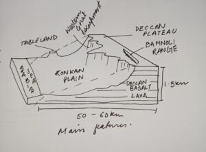 Volcanic eruptions, tectonic uplifts as well as long term erosions are some of the factors that have shaped Deccan Plateau presently with its elevated terrain, deep river valleys and fertile soils.

The earth's crust is constantly undergoing geological changes caused by internal and external forces which create new landforms. The external forces are working vigorously to wear away the surface and the interaction of these forces gives rise to present day landforms. The process is carried out inRead more
The earth’s crust is constantly undergoing geological changes caused by internal and external forces which create new landforms. The external forces are working vigorously to wear away the surface and the interaction of these forces gives rise to present day landforms. The process is carried out in four phases-
Aeolian landforms are produced by wind erosion and deposition process. This process produce a number of distinctive features-
- Mushroom rocks- these have been eroded, pitted, etched, grooved and polished by ice crystals or sand carried by wind.
- Yardangs- these are ridge separated parallel troughs carved into softer rock that runs in the direction of wind.
- Zeugen- these are the tabular masses which have a layer of soft rock laying beneath a surface of more resistant rock.
See less